|
KW YORK STATE GAZETTEER.
At Little Falls and “The Noses” the Mohawk breaks through mountain harriers in a deep, rocky
ravine; and at Cohoes, about 1 mile from its mouth, it flows down a perpendicular precipice of 70
feet, forming an excellent water-power. Below Troy the tributaries of the Hudson are all com¬
paratively small streams. South of the Highlands the river spreads out into a wide expanse known
as “Tappan Bay.” A few small streams upon the extreme e. border of the State flow eastward
into the Housatonic; and several small branches of Passaic River rise in the s. part of Rockland co.
Lake Erie forms a portion of the w. boundary of the State. It is 240 miles long, with an average
width of 38 miles, and it lies mostly w. of the' bounds of the State. It is 334 feet above Lake On¬
tario, 565 feet above tide, and has an average depth of 120 feet. The greatest depth ever obtained
by soundings is 270 feet. The harbors upon the lake are Buffalo, Silver Creek, Dunkirk, and
Barcelona.
Niagara River, forming the outlet of Lake Erie, is 34 miles long, and, on an average, more
than a mile wide.1 About 26 miles below Lake Erie .the rapids commence; and 2 miles further
below are Niagara Falls.2 For 7 miles below the falls the river has a rapid course between
perpendicular, rocky banks, 200 to 300 f&jjt high; but below it emerges from the Highlands and
flows 7 miles to Lake Ontario in a broad, ueep, and majestic current.
Lake Ontario forms a part of the n. boundary to the w. half of the State. Its greatest length is
130 miles and its greatest width 55 miles. It is 232 feet above tide, and its greatest depth is 600
feet. Its principal harbors on the American shore are Lewiston, Youngston, Port Genesee, Sodus
and Little Sodus Bays, Oswego, Sackets Harbor, and Cape Yincent. St. Lawrence River forms
the outlet of the lake and the n. boundary of the State to the e. line of St. Lawrence co. It is a
broad, deep river, flowing with a strong yet sluggish current until it passes the limits of this
State. In the upper part of its course it incloses a great number of small islands, known as
“ The Thousand Islands.”3 *
The surfaces of the great lakes are subject to variations of level,—probably due to prevailing
winds, unequal amounts of rain, and evaporation. The greatest difference known in Lake Erie is
7 feet, and in Lake Ontario 4f feet. The time of these variations is irregular; and the interval
between the extremes often extends through several years. A sudden rise and fall, of several
feet, has been noticed upon Lake Ontario at rare intervals, produced by some unknown cause.
Navigable Waters.—The natural internal navigation of the State is very extensive.
Before the commencement of internal improvements, the rivers and lakes formed the most easy
means of communication between distant portions- of the State; and along these natural channels
of commerce the early settlements were principally made.1 The most important lines of early
|
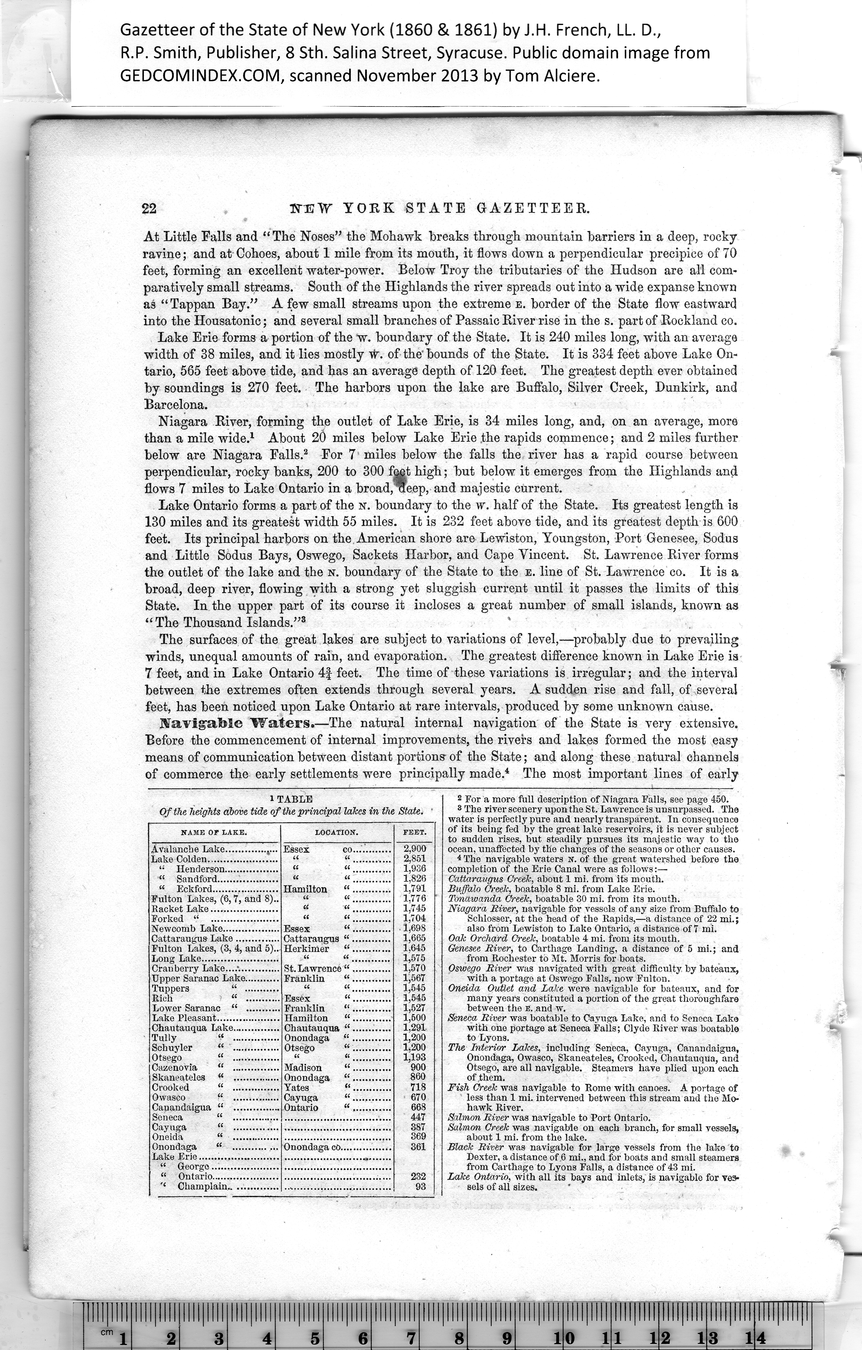
1 TABLE
Of the heights above tide of the principal lakes in the State. |
|
NAME OF LAKE. |
LOCATION. |
FEET. |
|
|
|
2,900 |
|
|
|
2,851
1,936 |
|
|
it it |
|
|
it it |
1,826
1,791 |
|
|
|
|
Fulton Lakes, (6, 7, and 8).. |
it it |
1,776
1,745 |
|
it it |
|
|
it it |
1,704 |
|
|
|
1,698
1,665
1.645 |
|
|
|
|
Fulton Lakes, (3, 4, and 5).. |
|
|
a it |
1,575 |
|
Cranberry Lake....*............. |
|
1,570
1,567 |
|
|
|
|
a it |
1.545
1.545
1,527
1,500 |
|
|
|
|
|
|
|
|
|
|
|
|
1,291
1,200 |
|
Tully “ ............... |
|
|
|
|
1.200
1,193
900 |
|
|
|
|
|
|
|
|
|
860 |
|
|
|
718 |
|
|
|
670 |
|
|
|
668 |
|
|
|
447 |
|
|
|
387 |
|
|
|
369 |
|
|
|
361 |
|
|
|
|
|
|
|
|
|
|
232 |
|
|
|
93 |
|
|
|
|
|
2 For a more full description of Niagara Falls, see page 450.
3 The river scenery upon the St. Lawrence is unsurpassed. The
water is perfectly pure and nearly transparent. In consequence
of its being fed by the great lake reservoirs, it is never subject
to sudden rises, but steadily pursues its majestic way to the
ocean, unaffected by the changes of the seasons or other causes.
. 4 The navigable waters n. of the great watershed before the
completion of the Erie Canal were as follows:—
Cattaraugus Creek, about 1 mi. from its mouth.
Buffalo Creelc, boatable 8 mi. from Lake Erie.
Tonawanda Oreek, boatable 30 mi. from its mouth.
Niagara River, navigable for vessels of any size from Buffalo to
Schlosser, at the head of the Bapids,—a distance of 22 mi.;
also from Lewiston to Lake Ontario, a distance of 7 mi.
Oak Orchard Creek, boatable 4 mi. from its mouth.
Genesee River, to Carthage Landing, a distance of 5 mi.; and
from Rochester to Mt. Morris for boats.
Oswego River was navigated with great difficulty by bateaux,
with a portage at Oswego Falls, now Fulton.
Oneida Outlet and Lake were navigable for bateaux, and for
many years constituted a portion of the great thoroughfare
between the E. and w.
Seneca River was boatable to Cayuga Lake, and to Seneca Lake
with one portage at Seneca Falls; Clyde River was boatable
to Lyons.
The Interior Lakes, including Seneca, Cayuga, Canandaigua,
Onondaga, Owasco, Skaneateles, Crooked, Chautauqua, and
Otsego, are all navigable. Steamers have plied upon each
of them.
Fish Creek was navigable to Rome with canoes. A portage of
less than 1 mi. intervened between this stream and the Mo¬
hawk River.
Salmon River was navigable to Port Ontario.
Salmon Creek was navigable on each branch, for small vessels,
about 1 mi. from the lake.
Black River was navigable for large vessels from the lake to
Dexter, a distance of 6 mi., and for boats and small steamers
from Carthage to Lyons Falls, a distance of 43 mi.
Lake Ontario, with all its bays and inlets, is navigable for ves¬
sels of all sizes. |
|