|
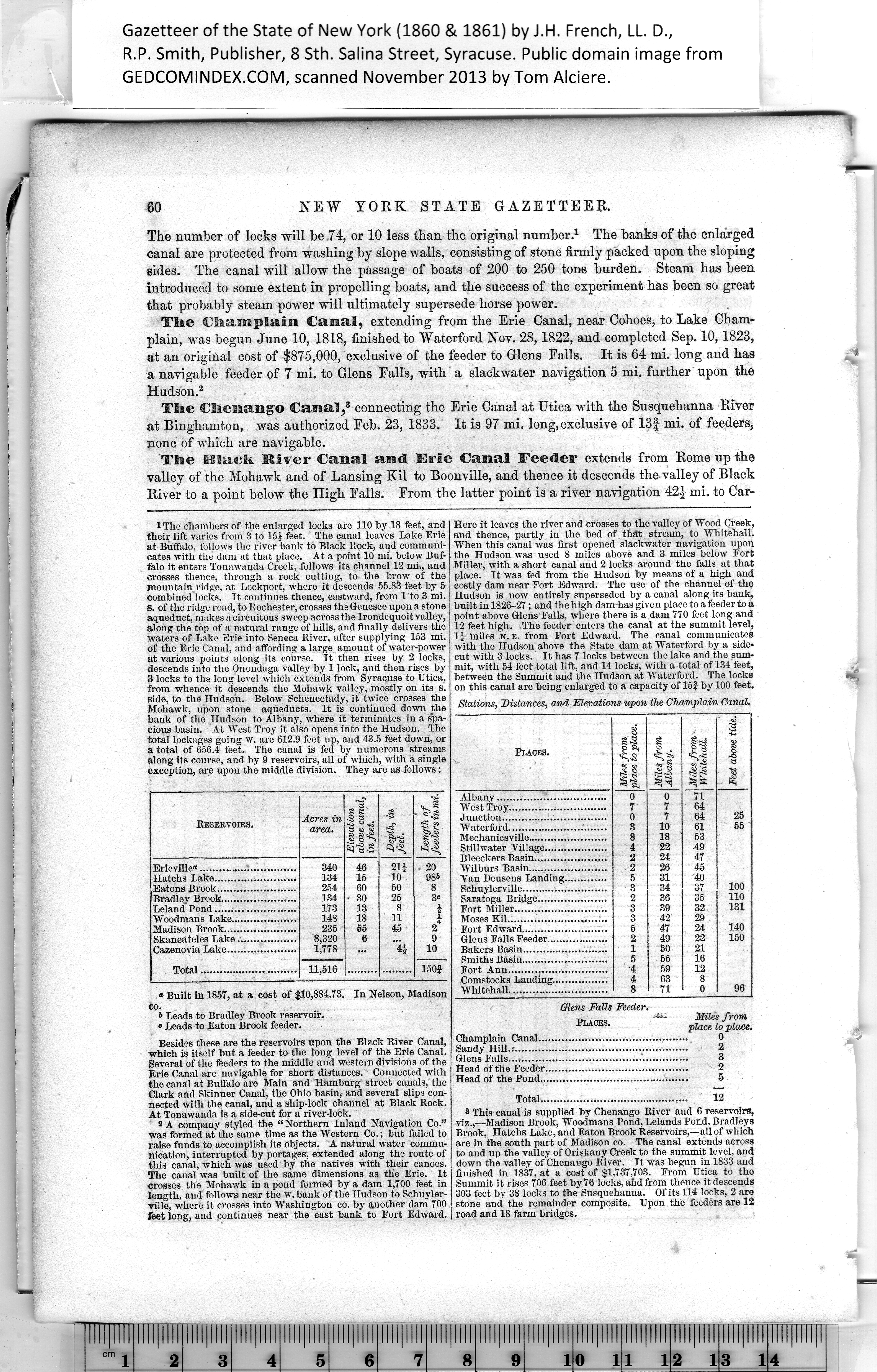
1 The chambers of the enlarged locks are 110 by 18 feet, and
their lift varies from 3 to 15 f feet. The canal leaves Lake Erie
at Buffalo, follows the river bank to Black Bock, and communi¬
cates with the dam at that place. At a point 10 mi. below Buf¬
falo it enters Tonawanda Creek, follows its channel 12 mi., and
crosses thence, through a rock cutting, to the brow of the
mountain ridge, at Lockport, where it descends 55.85 feet by 5
combined locks. It continues thence, eastward, from 1 to 3 mi.
S. of the ridge road, to Rochester, crosses the Genesee upon a stone
aqueduct, makes a circuitous sweep across the Irondequoitvalley,
along the top of a natural range of hills, and finally delivers the
waters of Lake Erie into Seneca River, after supplying 153 mi.
of the Erie Canal, and affording a large amount of water-power
at various points along its course. It then rises by 2 locks,
descends into the Onondaga valley by 1 lock, and then rises by
3 locks to the long level which extends from Syracuse to Utica,
from whence it descends the Mohawk valley, mostly on its s.
side, to the Hudson. Below Schenectady, it twice crosses the
Mohawk, upon stone aqueducts. It is continued down the
bank of the Hudson to Albany, where it terminates in a spa¬
cious basin. At West Troy it also opens into the Hudson. The
total lockages going w. are 612.9 feet Up, and 43.5 feet down, or
a total of 656.4 feet. The canal is fed by numerous streams
along Its course, and by 9 reservoirs, all of which, with a single
exception, are upon the middle division. They are as follows:
|
Reservoirs. |
Acres in
area. |
Elevation
above canal,
in feet. |
Depth, in
feet. |
Length of
feeders in mi. |
|
Erieville®........................ |
340 |
46 |
21f |
. 20 |
|
Hatchs Lake......................... |
134 |
15 |
10 |
984 |
|
Eatons Brook........................ |
254 |
60 |
50 |
8 |
|
Bradley Brook....................... |
134 |
• 30 |
25 |
3« |
|
Leland Pond........................ |
173 |
13 |
8 |
A |
|
Woodmans Lake.................... |
148 |
18 |
11 |
A |
|
Madison Brook...................... |
235 |
55 |
45 |
2 |
|
Skaneateles Lake.................. |
8,320 |
6 |
|
9 |
|
Cazenovia Lake..................... |
1,778 |
|
41 |
10 |
|
|
11,516 |
|
|
150} |
|
|
|
|
« Built in 1857, at a cost of $10,884.73. In Nelson, Madison
co.
4 Leads to Bradley Brook reservoir.
« Leads to Eaton Brook feeder.
Besides these are the reservoirs upon the Black River Canal,
which is itself but a feeder to the long level of the Erie Canal.
Several of the feeders to the middle and western divisions of the
Erie Canal are navigable for short distances. Connected with
the canal at Buffalo are Main and Hamburg street canals, the
Clark and Skinner Canal, the Ohio basin, and several slips con¬
nected with the canal, and a ship-lock channel at Black Rock.
At Tonawanda is a side-cut for a river-lock.
2 A company styled the “ Northern Inland Navigation Co.”
was formed at the same time as the Western Co.; but failed to
raise funds to accomplish its objects. A natural water commu¬
nication, interrupted by portages, extended along the route of
this canal, which was used by the natives with their canoes.
The canal was built of the same dimensions as the Erie. It
crosses the Mohawk in a pond formed by a dam 1,700 feet in
length, and follows near the w. bank of the Hudson to Schuyler-
viile, where it crosses into Washington co. by another dam 700
feet long, and continues near the east bank to Fort Edward. |
Here it leaves the river and crosses to the valley of Wood Creek,
and thence, partly in the bed of that stream, to WhitehaU.
When this canal was first opened slackwater navigation upon
the Hudson was used 8 miles above and 3 miles below Fort
Miller, with a short canal and 2 locks around the falls at that
place. It was fed from the Hudson by means of a high and
costly dam near Fort Edward. The use of the channel of the
Hudson is now entirely superseded by a canal along its bank,
built in 1826-27; and the high dam has given place to a feeder to a
point above Glens Falls, where there is a dam 770 feet long and
12 feet high. The feeder enters the canal at the summit level,
If miles n. e. from Fort Edward. The canal communicates
with the Hudson above the State dam at Waterford by a side-
cut with 3 locks. It has 7 locks between tho lake and the sum¬
mit, with 54 feet total lift, and 14 locks, with a total of 134 feet,
between the Summit and the Hudson at Waterford. The locks
on this canal are being enlarged to a capacity of 15} by 100 feet.
Miles from
place to place.
0
,. 2
3
2
5
|
Stations, Distances, and Elevations upon the Champlain Canal. |
|
Places. |
Miles from
place to place. |
Miles from
Albany. |
£ a
<C.sS
*?-s
•sS |
Feet above tide. |
|
Albany................................. |
0 |
0 |
71 |
|
|
West Troy.............................. |
7 |
7 |
64 |
|
|
Junction................................ |
0 |
7 |
64 |
25 |
|
Waterford.............................. |
3 |
10 |
61 |
55 |
|
Mechanicsville........................ |
8 |
18 |
53 |
|
|
Stillwater Village................... |
4 |
22 |
49 |
|
|
Bleeckers Basin...................... |
2 |
24 |
47 |
|
|
Wilburs Basin........................ |
. 2 |
26 |
45 |
|
|
Van Deusens Landing............. |
5 |
31 |
40 |
|
|
Schuylerville.......................... |
3 |
34 |
37 |
100 |
|
Saratoga Bridge..................... |
2 |
36 |
35 |
110 |
|
Fort Miller............................ |
3 |
39 |
32 |
131 |
|
Moses Kil.............................. |
3 |
42 |
29 |
|
|
Fort Edward.......................... |
5 |
47 |
24 |
140 |
|
Glens Falls Feeder................... |
2 |
49 |
22 |
150 |
|
Bakers Basin.......................... |
1 |
50 |
21 |
|
|
Smiths Basin.......................... |
5 |
55 |
16 |
|
|
Fort Ann.............................. |
4 |
59 |
12 |
|
|
Comstocks Landing................. |
4 |
63 |
8 |
|
|
Whitehall.............................. |
8 |
71 |
0 |
96 |
|
|
Glens Falls
Places. |
Champlain Canal....
Sandy Hill..*...........
Glens Falls............
Head of the Feeder..
Head of the Pond...
Total......................................... 12
8 This canal is supplied by Chenango River and 6 reservoirs,
viz.,—Madison Brook, Woodmans Pond, Lelands Por.d. Bradleys
Brook, Hatchs Lake, and Eaton Brook Reservoirs,—all of which
are in the south part of Madison co. The canal extends across
to and up the valley of Oriskany Creek to the summit level, and
down the valley of Chenango River. It was begun in 1833 and
finished in 1837, at a cost of $1,737,703. From Utica to the
Summit it rises 706 feet by 76 locks, afid from thence it descends
303 feet by 38 locks to the Susquehanna. Of its 114 locks, 2 are
stone and the remainder composite. Upon the feeders are 12
road and 18 farm bridges. |