|
COMMERCE. 121
Lifeboat Stations have also been established by the General Government upon the sea-
coast and great lakes. On the shores of Long Island and the adjacent islands are 30 lifeboat sta¬
tions, the first of which were established about 1850. Each of these consists of a house, containing
a lifeboat, boat wagon, life cars, mortar for throwing lines, and every fisture that could be used in
affording aid to vessels in distress. The houses are furnished with stoves for warming them when
necessary, and with fuel and matches for kindling a fire on short notice. They are each intrusted
to a local agent, and are under the general care of a superintendent appointed by the Secretary of
the Treasury. Their location is indicated on the map.
€k>a§t Survey.—A survey of the coast, with soundings of its adjacent waters, was ordered
by the General Government about 50 years since; but many years were necessarily employed in
making preliminary arrangements. Active surveys were begun about 1832, and during the
last 15 years they have been prosecuted with great effect. The triangulations of this survey
are conducted with great precision, and extend up all rivers navigable from the sea as far as
tide flows.
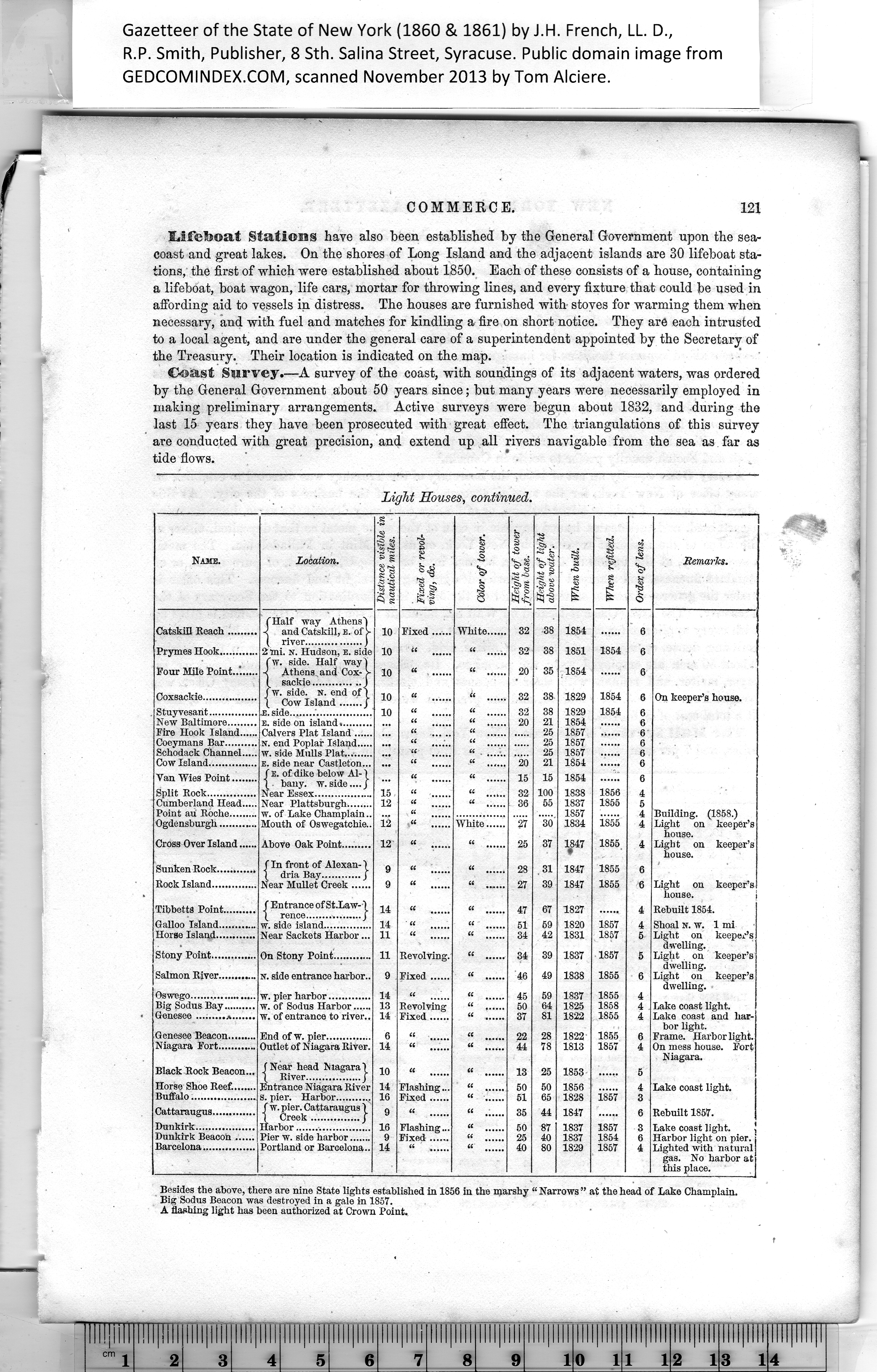
Light Houses, continued.
|
fin front of Alexan-)
| dria Bay............j
Near Mullet Creek.....
w. pier harbor.............
w. of Sodus Harbor......
W. of entrance to river.. |
|
Distance visible in
nautical miles. |
Fixed or revol-
j ving, Sc. |
Color of tower. |
I Height of tower
\ from base. |
1 Height of light
1 above water. |
When buiU. |
When refitted. |
j Order of lens. |
Remarks. |
|
10 |
Fixed...... |
Wliite...... |
32 |
38 |
1854 |
|
6 |
|
|
10 |
(( |
66 |
32 |
38 |
1851 |
1854 |
6 |
|
|
10 |
66 |
66 |
20 |
35 |
1854 |
|
6 |
|
|
10 |
« |
66 |
32 |
38 |
1829 |
1854 |
6 |
On keeper’s house. |
|
10 |
« |
66 |
32 |
38 |
1829 |
1854 |
6 |
|
|
|
66 |
66 |
20 |
21 |
1854 |
|
6 |
|
|
|
66 |
“ ...... |
|
25 |
1857 |
|
6 |
|
|
|
66 |
ii |
|
25 |
1857 |
|
6 |
|
|
|
66 |
ii |
|
25 |
1857 |
|
6 |
|
|
|
“ ...... |
|
20 |
21 |
1854 |
|
6 |
|
|
|
(6 |
ii |
15 |
15 |
1854 |
|
6 |
|
|
15 |
|
66 |
32 |
100 |
1838 |
1856 |
4 |
|
|
12 |
66 |
66 |
36 |
55 |
1837
1857 |
1855 |
5
4 |
Building. (1858.) |
|
i.2 |
66 ...... |
White...... |
27 |
30 |
1834 |
1855 |
4 |
Light on keeper’s
house. |
|
12 |
a |
66 |
25 |
37 |
1847 |
1855 |
4 |
Light on keeper’s
house. |
|
9 |
a |
66 |
28 |
31 |
1847 |
1855 |
6 |
|
|
9 |
“ ...... |
« ...... |
27 |
39 |
1847 |
1855 |
6 |
Light on keeper’s
house. |
|
14 |
66 |
« ...... |
47 |
67 |
1827 |
|
4 |
Rebuilt 1854. |
|
14 |
" ii |
« |
51 |
59 |
1820 |
1857 |
4 |
Shoal N. w. 1 mi |
|
11 |
66 |
66 ...... |
34 |
42 |
1831 |
1857 |
5 |
Light on keeper’s
dwelling. |
|
11 |
Revolving. |
CC ...... |
34 |
39 |
1837 |
1857 |
5 |
Light , on keeper’s
dwelling. |
|
9 |
Fixed...... |
66 |
46 |
49 |
1838 |
1855 |
6 |
Light on keeper’s
dwelling. |
|
14 |
tt |
66 |
45 |
59 |
1837 |
1855 |
4 |
|
13 |
Revolving |
“ ...... |
50 |
64 |
1825 |
1858 |
4 |
Lake coast light. |
|
14 |
Fixed...... |
66 |
37 |
81 |
1822 |
1855 |
4 |
Lake coast and har¬
bor light. |
|
6 |
tt |
66 |
22 |
28 |
1822 |
1855 |
6 |
Frame. Harbor light. |
|
14 |
it |
|
44 |
78 |
1813 |
1857 |
4 |
On mess house. Fort
Niagara. |
|
10 |
tt |
66 |
13 |
25 |
1853 |
|
5 |
|
|
14 |
Flashing ... |
66 |
50 |
50 |
1856 |
|
4 |
Lake coast light. |
|
16 |
Fixed...... |
66 |
51 |
65 |
1828 |
1857 |
3 |
|
9 |
“ ...... |
66 |
35 |
44 |
1847 |
|
6 |
Rebuilt 1857. |
|
16 |
Flashing... |
66 |
50 |
87 |
1837 |
1857 |
3 |
Lake coast light. |
|
9 |
Fixed ...... |
66 |
25 |
40 |
1837 |
1854 |
6 |
Harbor light on pier. |
|
14 |
|
66 |
40 |
80 |
1829 |
1857 |
4 |
Lighted with natural
gas. No harbor at
this place. |
|
(Half way Athens')
-c and Catskill, e. of L
( river.................)
2 mi. sr. Hudson, e. side
'w. side. Half way )
Athens, and Cox- L
sackie..............j
fw. side. N. end of 1
| Cow Island j
.E. side .................
e. side on island..........
Calvers Plat Island......
N. end Poplar Island.....
w. side Mulls Plat.........
e. side near Castleton...
f e. of dike below Al-1
bany. w. side.... j
Near Essex..................
Near Plattsburgh........
w. of Lake Champlain..
Mouth of
Catskill Reach......
Prymes Hook.........
Four Mile Point.."..
Coxsackie..............
Stuyvesarit............
New Baltimore.......
Fire Hook Island...
Coeymans Bar.......
Schodack Channel..
Cow Island............
Van Wies Point.....
Split Rock............
Cumberland Head..
Point au Roche......
Ogdensburgh.........
Cross Over Island.
Sunken Rock.,
Rock Island...
f Entrance of St.Law-1
\ rence.................j
w. side island...............
Near Sackets Harbor ...
On Stony Point............
N. side entrance harbor..
Tibbetts Point..
Galloo Island...
Horse Island....
Stony Point....
Salmon River..
Oswego.....
Sodus;
Genesee Beacon..
Niagara Fort.....
End of w. pier..............
Outlet of Niagara River.
(Near head Niagara)
\ River.................j
Entrance Niagara River
. pier. Harbor ..
f w. pier. Cattaraugus I
[ Creek...............j"
Harbor ...............
Pier w. side harbor.......
Portland or Barcelona..
Black Rock Beacon.,
Horse Shoe Reef......
Buffalo..................
Dunkirk.............
Dunkirk Beacon ,
Barcelona..........
Besides the above, there are nine State lights established in 1856 in the marshy “ Narrows ” at the head of Lake Champlain.
Big Sodus Beacon was destroyed in a gale in 1857.
A flashing light has been authorized at Crown Point.
|