Click on the image for a larger version suitable for printing. HOME PAGE ... REFERENCE PAGE ...THIS GAZETTEER’S PAGE |
|
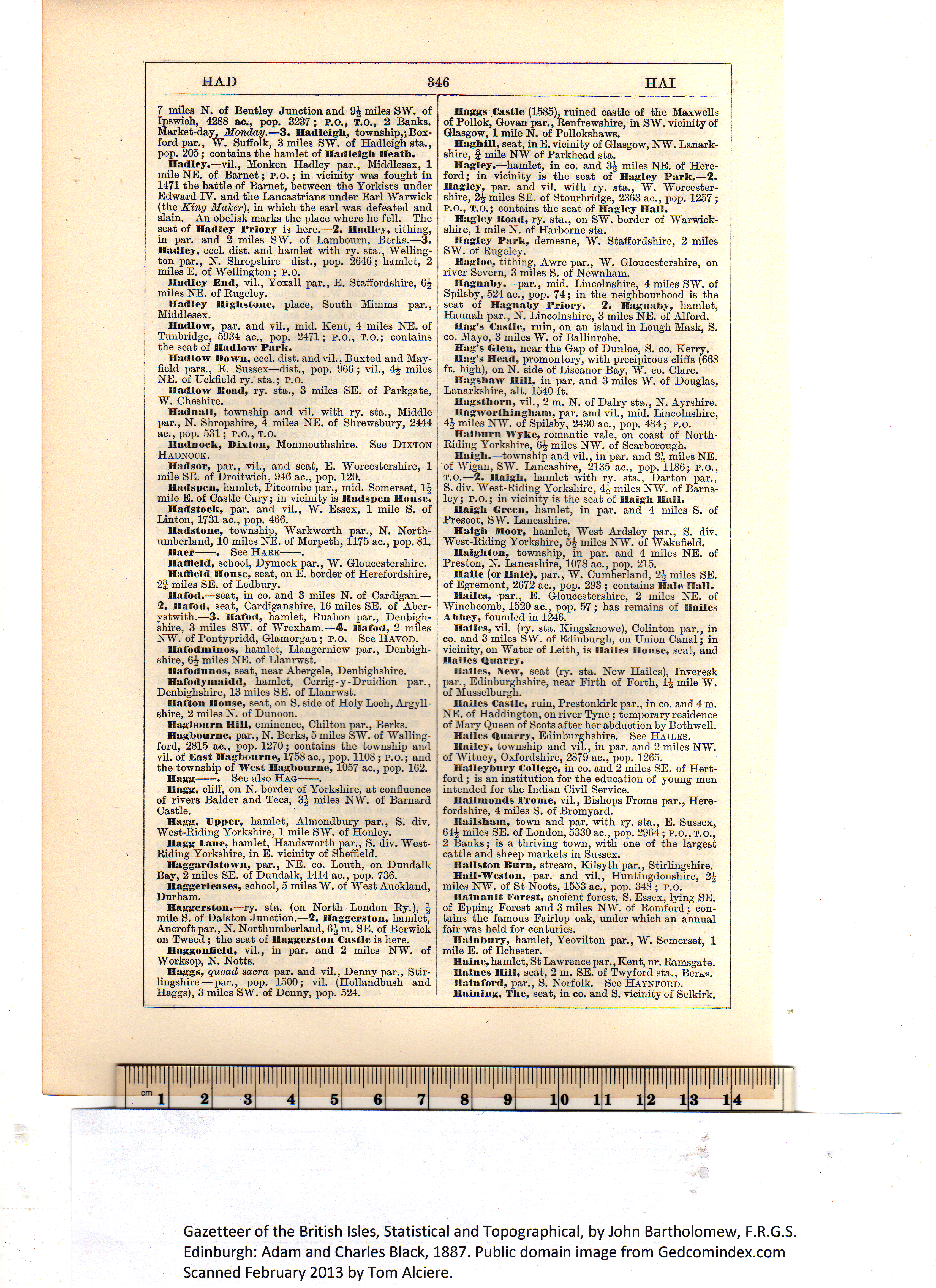
Haggs Castle (1585), ruined castle of the Maxwells Haghill, seat, in E. vicinity of Glasgow, NW. Lanark- Hagley.—hamlet, in co. and 3¼ miles NE. of Here- Hagley Road, ry. sta., on SW. border of AYarwick- Hagley Park, demesne, W. Staffordshire, 2 miles Hagloc, tithing, Awre par., W. Gloucestershire, on Hagnaby.—par., mid. Lincolnshire, 4 miles SW. of Hag’s Castle, ruin, on an island in Lough Mask, S. Hag’s Glen, near the Gap of Dunloe, S. co. Kerry. Hag’s Head, promontory, with precipitous cliffs (668 Hagsliaw Hill, in par. and 3 miles AY. of Douglas, Hagsthorn, vil., 2 m. N. of Dairy sta., N. Ayrshire. Hagworthingliain, par. and vil., mid. Lincolnshire, Halbnrn Wykc, romantic vale, on coast of North- Ilaigli.—township and vil., in par. and 2¼ miles NE. Haigh Green, hamlet, in par. and 4 miles S. of Haigh Moor, hamlet, West Ardsley par., S. div. Haighton, township, in par. and 4 miles NE. of Haile (or Hale), par., W. Cumberland, 2¼ miles SE. Hailes, par., E. Gloucestershire, 2 miles NE. of Hailes, vil. (ry. sta. Kingsknowe), Colinton par., in Hailes, New, seat (ry. sta. New Hailes), Inveresk Hailes Castle, ruin, Prestonkirk par., in co. and 4 m. Hailes Quarry, Edinburghshire. See Hailes. Hailey, township and vil., in par. and 2 miles NW. Haileybury College, in co. and 2 miles SE. of Hert- Hailmonds Froine, vil., Bishops Frome par., Here- Hailsham, town and par. with ry. sta., E. Sussex, Uailston Burn, stream, Kilsyth par., Stirlingshire. Hail-Weston, par. and vil., Huntingdonshire, 2¼ Hainanlt Forest, ancient forest, S. Essex, lying SE. llninbury, hamlet, Yeovilton par., W. Somerset, 1 Haine, hamlet, St Lawrence par., Kent, nr. Ramsgate. Haines Hill, seat, 2 m. SE. of Twyford sta., Ber^«. llalnford, par., S. Norfolk. See Haynford. llaining, The, seat, in co. and S. vicinity of Selkirk. Gazetteer of the British Isles, Statistical and Topographical, by John Bartholomew, F.R.G.S. Edinburgh: Adam and Charles Black, 1887. Public domain image from Gedcomindex.com |
Click on the image to get a large bitmap suitable for printing (45 MB) |
This page is written in HTML using a program written in Python 3.2, and image-to-HTML-text by ABBYY FineReader 11 Professional Edition.