|
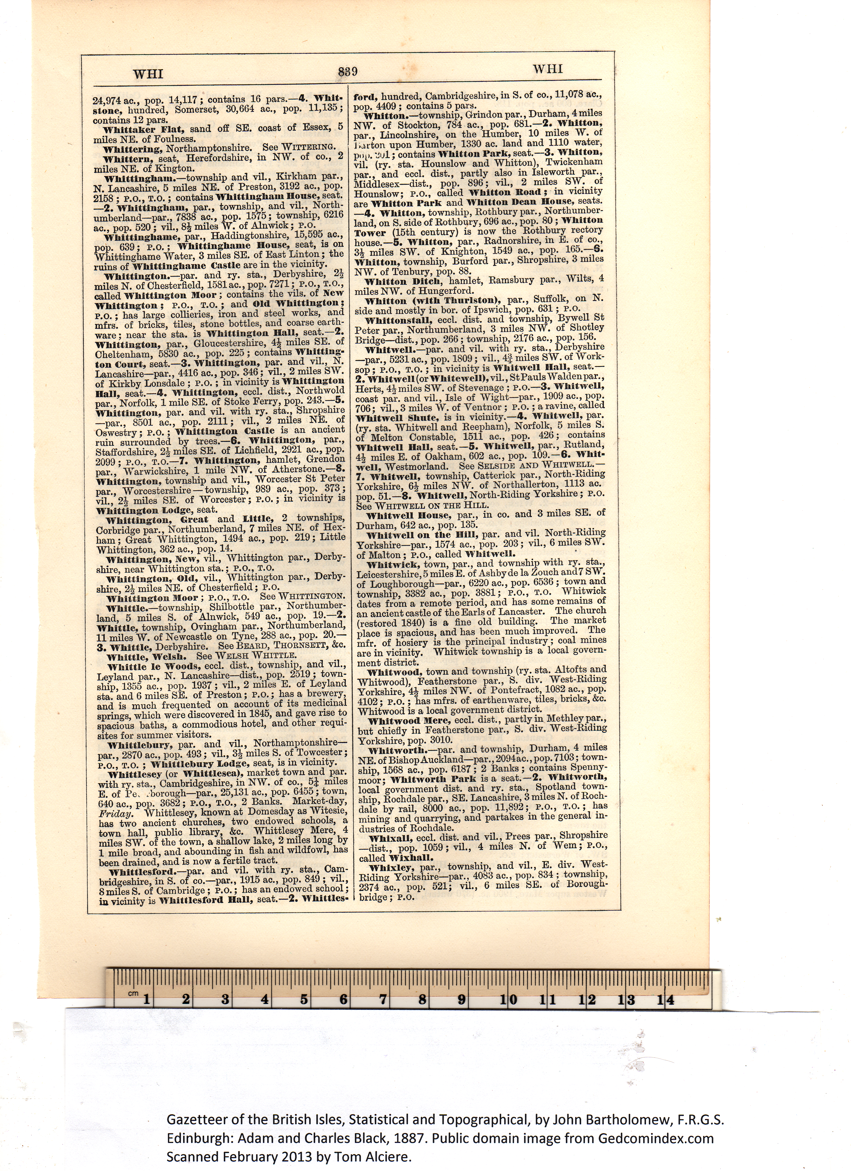
Whitton.—township, Grindon par., Durham, 4 miles
NW. of Stockton, 784 ac., pop. 681.—2. Whitton,
par., Lincolnshire, on the Humber, 10 miles W. of
Barton upon Humber, 1330 ac. land and 1110 water,
pop. 2ul; contains Whitton Park, seat.—3. Whitton,
vil. (ry. sta. Hounslow and Whitton), Twickenham
par., and eccl. dist., partly also in Isleworth par.,
Middlesex—dist., pop. 896; vil., 2 miles SW. of
Hounslow; P.O., called Whitton Boad; in vicinity
are Whitton Park and Whitton Dean Honse, seats.
—4. Whitton, township, Rothbury par., Northumber-
land, on S. side of Rothbury, 696 ac., pop. 80 ; Whitton
Tower (15th century) is now the Rothbury rectory
house.—5. Whitton, par., Radnorshire, in E. of co.,
3% miles SW. of Knighton, 1549 ac., pop. 165.—6.
Whitton, township, Burford par., Shropshire, 3 miles
NW. of Tenbury, pop. 88.
Whitton Ditch, hamlet, Ramsbury par., AVilts, 4
miles NW. of Hungerford.
Whitton (with Thurlston), par., Suffolk, on N.
side and mostly in bor. of Ipswich, pop. 631; P.O.
WhittonstaU, eccl. dist. and township, Bywell St
Peter par., Northumberland, 3 miles NW. of Shotley
Bridge—dist., pop. 266; township, 2176 ac., pop. 156.
Whitwell.—par. and vil. with ry. sta., Derbyshire
—par., 5231 ac., pop. 1809; vil., 4f miles SW. of Work- !
sop; P.O., T.O.; in vicinity is Whitwell Hall, seat.— j
2. Whitwell(or Whttewell), vil., StPauls Waldenpar.,
Herts, 4% miles SW. of Stevenage ; P.O.—3. Whitwell,
coast par. and vil., Isle of AVight—par., 1909 ac., pop.
706; vil., 3 miles AV. of Yentnor ; P.O.; a ravine, called
Whitwell Shute, is in vicinity.—4. Whitwell, par.
(ry. sta. Whitwell and Reepham), Norfolk, 5 miles S.
of Melton Constable, 1511 ac., pop. 426; contains
Whitwell Hall, seat.—5. Whitwell, par., Rutland,
4% miles E. of Oakham, 602 ac., pop. 109.—6. Whit-
well, Westmorland. See Selside and Whitwell.—
7. Whitwell, township, Catterick par., North-Riding
Yorkshire, 6% miles NAV. of Northallerton, 1113 ac.
pop. 51.—8- Whitwell, North-Riding Yorkshire; P.O.
See Whitwell on the Hill.
Whitwell House, par., in co. and 3 miles SE. of
Durham, 642 ac., pop. 135. i
Whitwell on the 11111, par. and vil. North-Riding
Yorkshire—par., 1574 ac., pop. 203; vil., 6 miles SAV. t
of Malton; P.O., called Whitwell.
Whitwick, town, par., and township with ry. sta., J
Leicestershire, 5 miles E. of Ashby de la Zouch and 7 SW. j
of Loughborough—par., 6220 ac., pop. 6536 ; town and j
township, 3382 ac., pop. 3881; P.O., T.o. Whitwick \
dates from a remote period, and has some remains of i
an ancient castle of the Earls of Lancaster. The church
(restored 1840) is a fine old building. The market
place is spacious, and has been much improved. The
mfr. of hosiery is the principal industry; coal mines
are in vicinity. Whitwick township is a local govern-
ment district.
Whitwood, town and township (ry. sta. Altofts and
AVhitwood), Featherstone par., S. div. West-Riding
Yorkshire, 4% miles NW. of Pontefract, 1082 ac., pop.
4102; P.O.; has mfrs. of earthenware, tiles, bricks, &c.
Whitwood is a local government district.
Whitwood Mere, eccl. dist., partly in Methleypar.,
but chiefly in Featherstone par., S. div. West-Riding
Yorkshire, pop. 3010.
Whitworth.—par. and township, Durham, 4 miles
NE. of Bishop Auckland—par., 2094ae., pop. 7103; town-
ship, 1568 ac., pop. 6187; 2 Banks; contains Spenny-
moor; Whitworth Park is a seat.—2. Whitworth,
local government dist. and ry. sta., Spotland town-
ship, Rochdale par., SE. Lancashire, 3 miles N. of Roch-
dale by rail, 8000 ac., pop. 11,892; P.O., t.o.; has
mining and quarrying, and partakes in the general in-
dustries of Rochdale.
Whixall, eccl. dist. and vil., Prees par., Shropshire
—dist., pop. 1059; vil., 4 miles N. of Wem; P.O.,
called Wlxhall.
Whixley, par., township, and vil., E. div. West-
Riding Yorkshire—par., 4083 ac., pop. 834 ; township,
2374 ac., pop. 521; vil., 6 miles SE. of Borough-
bridge; P.O. Gazetteer of the British Isles, Statistical and Topographical, by John Bartholomew, F.R.G.S.
Edinburgh: Adam and Charles Black, 1887. Public domain image from Gedcomindex.com
|

Click on the image to get a large bitmap suitable for printing (45 MB) |