|
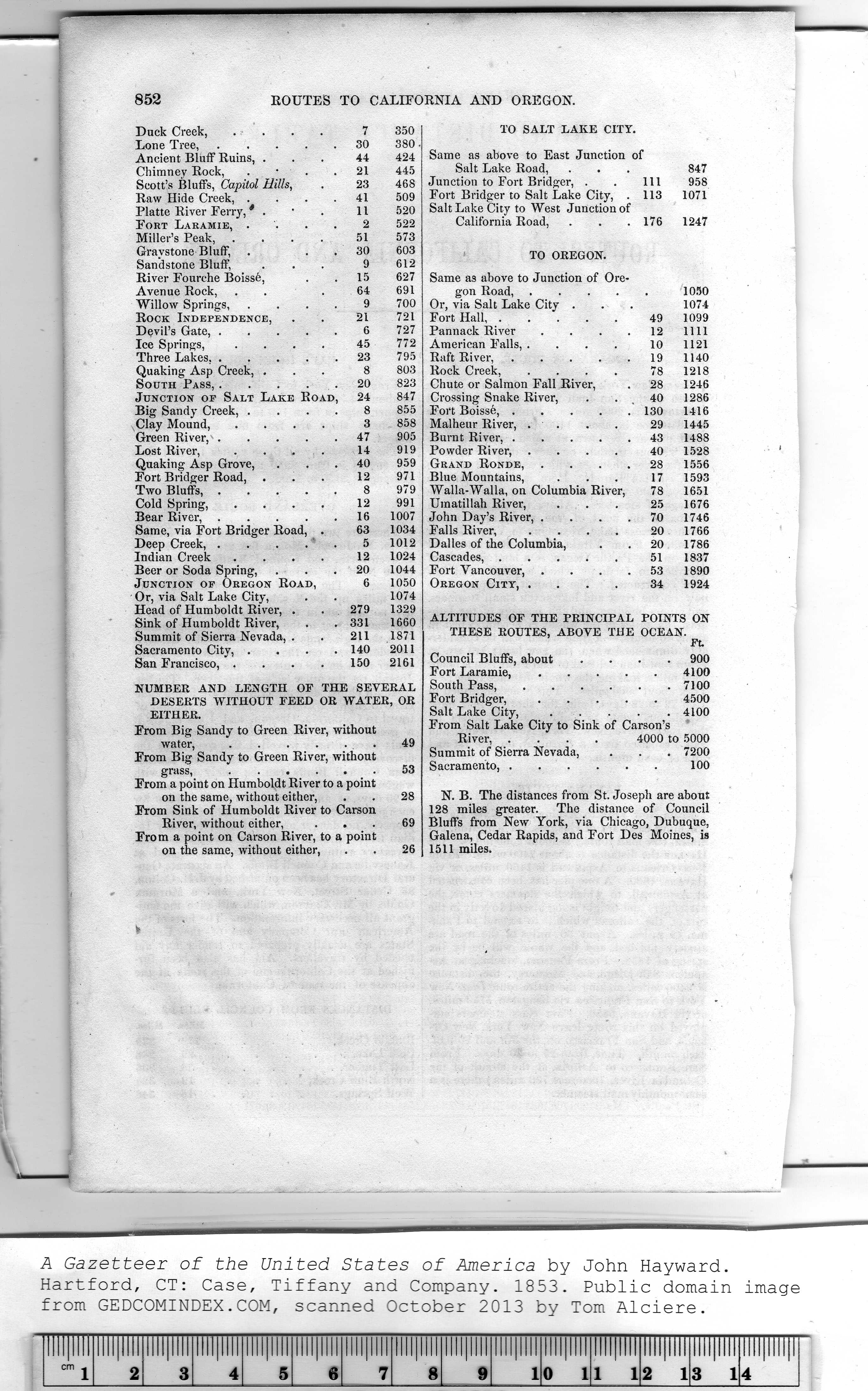
Duck Creek, . . . . 7 350
Lone Tree,..... 30 380
Ancient Bluff Ruins, ... 44 424
Chimney Rock, 21 445
Scott's Bluffs, Capitol Hills, . 23 468
Raw Hide Creek, .... 41 509
Platte River Ferry, * . • . 11 520
Fort Laramie, .... 2 522
Miller's Peak, . . . . 51 573
Gravstone Bluff, . 30 603
Sandstone Bluff, . . . 9 612
River Fourche Boissfe, . . 15 627
Avenue Rock, . . . 64 691
Willow Springs, .... 9 700
Rock Independence, . . 21 721
Devil's Gate,..... 6 727
Ice Springs, .... 45 772
Three Lakes,..... 23 795
Quaking Asp Creek, ... 8 803
South Pass, . . . 20 823
Junction op Salt Lake Road, 24 847
Big Sandy Creek, .... 8 855
Clay Mound, .... 3 858
Green River,..... 47 905
Lost River, . . . . 14 919
Quaking Asp Grove, ... 40 959
Fort Bridger Road, ... 12 971
Two Bluffs,..... 8 979
Cold Spring, . . . . 12 991
Bear River,.....16 1007
Same, via Fort Bridger Road, . 63 1034
Deep Creek, . . . . . 5 1012
Indian Creek . . . . 12 1024
Beer or Soda Spring, ... 20 1044
Junction op Oregon Road, 6 1050
Or, via Salt Lake City, . . 1074
Head of Humboldt River, . . 279 1329
Sink of Humboldt River, . . 331 1660
Summit of Sierra Nevada, . . 211 1871
Sacramento City, .... 140 2011
San Francisco, . . . . 150 2161
NUMBER AND LENGTH OF THE SEVERAL
DESERTS WITHOUT FEED OR WATER, OR
EITHER.
From Big Sandy to Green River, without
water,..... 49
From Big Sandy to Green River, without
grass,......53
From a point on Humboldt River to a point
on the same, without either, . . 28
From Sink of Humboldt River to Carson
River, without either, ... 69
From a point on Carson River, to a point
on the same, without either, . . 26 |
TO SALT LAKE CITY.
Same as above to East Junction of
Salt Lake Road, . . . 847
Junction to Fort Bridger, . . Ill 958
Fort Bridger to Salt Lake City, . 113 1071
Salt Lake City to West Junction of
California Road, . . .176 1247
TO OREGON.
Same as above to Junction of Ore-
gon Road,.....1050
Or, via Salt Lake City . . . 1074
Fort Hall...... 49 1099
Pannack River . . . . 12 llll
American Falls, . ... 10 1121
Raft River,.....19 1140
Rock Creek, .... 78 1218
Chute or Salmon Fall River, . 28 1246
Crossing Snake River, . . 40 1286
Fort Boisse,.....130 1416
Malheur River, . . . . 29 1445
Burnt River,..... 43 1488
Powder River, .... 40 1528
Grand Ronde, .... 28 1556
Blue Mountains, . . . 17 1593
Walla-Walla, on Columbia River, 78 1651
Uinatillah River, ... 25 1676
John Day's River, . . . .70 1746
Falls River, .... 20 1766
Dalles of the Columbia, . . 20 1786
Cascades,.....51 1837
Fort Vancouver, .... 53 1890
Oregon City, .... 34 1924
ALTITUDES OF THE PRINCIPAL POINTS ON
THESE ROUTES, ABOVE THE OCEAN.
Ft.
Council Bluffs, about .... 900
Fort Laramie......4100
South Pass,......7100
Fort Bridger,..... 4500
Salt Lake City, . . . . . 4100
From Salt Lake City to Sink of Carson's
River, .... 4000 to 5000
Summit of Sierra Nevada, . . . 7200
Sacramento,......100
N. B. The distances from St. Joseph are about
128 miles greater. The distance of Council
Bluffs from New York, via Chicago, Dubuque,
Galena, Cedar Rapids, and Fort Des Moines, is
1511 miles. |