|
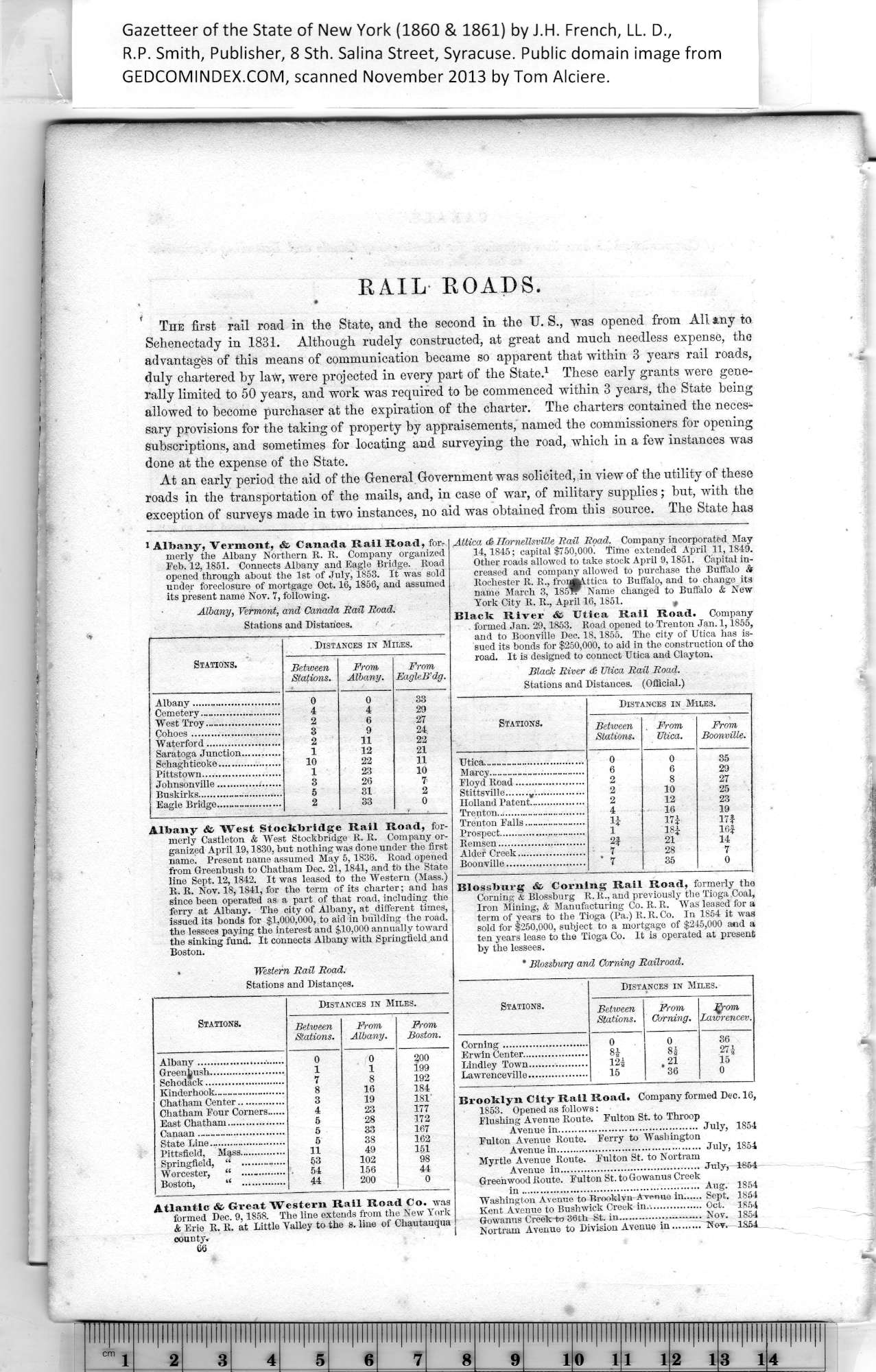
1 Albany, Vermont, & Canada Rail Road, for¬
merly the Albany Northern It. R. Company organized
Feb. 12,1851. Connects Albany and Eagle Bridge. Road
opened through about the 1st of July, 1853. It was sold
under foreclosure of mortgage Oct. 16, 1856, and assumed
its present name Nov. 7, following.
Albany, Vermont, and Canada Rail Road.
|
Stations and Distances. |
|
Stations. |
Distances in Miles. |
|
Between
Stations. |
From
Albany. |
From
EagleB’dg. |
|
Albany......_.................... |
0 |
0 |
33 |
|
Cemetery.™....................... |
4 |
4 |
29 |
|
West Troy....................... |
2 |
6 |
27 |
|
Cohoes............................ |
3 |
9 |
24 |
|
Waterford....................... |
2 |
11 |
22 |
|
Saratoga Junction............ |
1 |
12 |
21 |
|
Schaghtieoke.................... |
10 |
22 |
11 |
|
Pittstown........................ |
1 |
23 |
10 |
|
Johnsonville.................... |
3 |
26 |
7 |
|
Buskirks.......................... |
5 |
31 |
2 |
|
Eagle Bridge................... |
2 |
33 |
0 |
|
Albany St> West St.ockbridge Rail Road, for¬
merly Castleton & West Stockbridge R. R. Company or¬
ganized April 19,1830, but nothing was done under the first
name. Present name assumed May 5,1836. Road opened
from Greenbush to Chatham Dec. 21,1841, and to the State
line Sept. 12,1842. It was leased to the Western (Mass.)
R. R. Nov. 18,1841, for the term of its charter; and has
since been operated as a part of that road, including the
ferry at Albany. The city of Albany, at different times,
issued its bonds for $1,000,000, to aid in building the road,
the lessees paying the interest and $10,000 annually toward
the sinking fund. It connects Albany with Springfield and
Boston.
• Western Rail Road.
|
Stations and Distances. |
|
Stations. |
Distances in Miles. |
|
Between
Stations. |
From
Albany. |
From
Boston. |
|
Albany........................... |
0 |
0 |
200 |
|
Greenjush....................... |
1 |
1 |
199 |
|
Schodack......................... |
7 |
8 |
192 |
|
Kinderhook......................... |
8 |
16 |
184 |
|
Chatham Center.............. |
3 |
19 |
181 |
|
Chatham Four Corners...... |
4 |
23 |
177 |
|
East Chatham.................. |
5 |
28 |
172 |
|
Canaan .......................... |
5 |
33 |
167 |
|
State Line......................... |
5 |
38 |
162 |
|
Pittsfield, Mass............... |
11 |
49 |
151 |
|
Springfield, “ .............. |
53 |
102 |
98 |
|
Worcester, “ .—......... |
54 |
156 |
44 |
|
Boston, “ .............. |
44 |
200 |
0 |
|
|
Atlantic &> Great Western Rail Road Co. was
formed Dec. 9,1858. The line extends from the New York
& Erie R. R. at Little Valley to the s. line of Chautauqua
county.
66 |
|
Attica <6 Hornellsville Rail Road. Company incorporated May
14,1845; capital $750,000. Time extended April 11,1849.
Other roads allowed to take stock April 9,1851. Capital in¬
creased and company allowed to purchase the Buffalo &
Rochester R. R., froiMKVttica to Buffalo, and to change its
name March 3, 185w Name changed to Buffalo & New
York City R. R., April 16,1851. t
Black River & Utica Rail Road. Company
formed Jan. 29,1853. Road opened to Trenton Jan. 1,1855,
and to Boonville Dec. 18,1855. The city of Utica has is¬
sued its bonds for $250,000, to aid in the construction of the
road. It is designed to connect Utica and Clayton.
Black River <& Vlica Rail Road.
|
Stations and Distances. (Official.) |
|
Stations. |
Distances in Miles. |
|
Between
Stations. |
. From
Utica. |
From
Boonville. |
|
Utica............................... |
0 |
0 |
35 |
|
Marcy___________________________ |
6 |
6 |
29 |
|
Floyd Road..................... |
2 |
8 |
27 |
|
Stittsville.......v................ |
2 |
10 |
25 |
|
Holland Patent.................. |
2 |
12 |
23 |
|
Trenton............................... |
4 |
16 |
19 |
|
Trenton Falls.................... |
lj |
17i |
17$ |
|
Prospect.............................. |
1 |
18* |
16| |
|
Remsen........................... |
2$ |
21 |
14 |
|
Alder Creek..................... |
7 |
28 |
7 |
|
Boonville........................ |
’ 7 |
35 |
0 |
|
Blossburg & Corning Rail Road, formerly the
Corning & Blossburg R. R., and previously the Tioga Coal,
Iron Mining, & Manufacturing Co. R. R. Was leased for a
term of years to the Tioga (Pa.) R. R. Co. In 1854 it was
sold for $250,000, subject to a mortgage of $245,000 and a
ten years lease to the Tioga Co. It is operated at present
by the lessees.
|
* Blossburg and Corning Railroad. |
|
|
Distances in Miles. |
|
Stations. |
Between
Stations. |
From
Corning. |
Jgrom
Zawrencev. |
|
|
0 |
0 |
36 |
|
|
84 |
84 |
274 |
|
|
124 |
23. |
15 |
|
|
15 |
36 |
0 |
|
|
|
|
|
|
Brooklyn City Rail Road. Company formed Dec. 16, |
1853. Opened as follows:
Flushing Avenue Route. Fulton St. to Throop
Avenue in.......................................... July* 1854
Fulton Avenue Route. Ferry to Washington
Avenue in............................................ July, 1854
Myrtle Avenue Route. Fulton St. to Nortram
Avenue in.......................................... July, 1864
Greenwood Route. Fulton St. to Gowanus Creek
in...................................................... Aug. 1854
Washington Avenue to Brooklyn Avenue in Sept. 1854
Kent Avenue to Bushwick Creek in................. Oct. 1854
Gowanus Creek-to 36th St. in......................... Nov. 1854
Nortram Avenue to Division Avenue in.........Nov, 1S54 |
