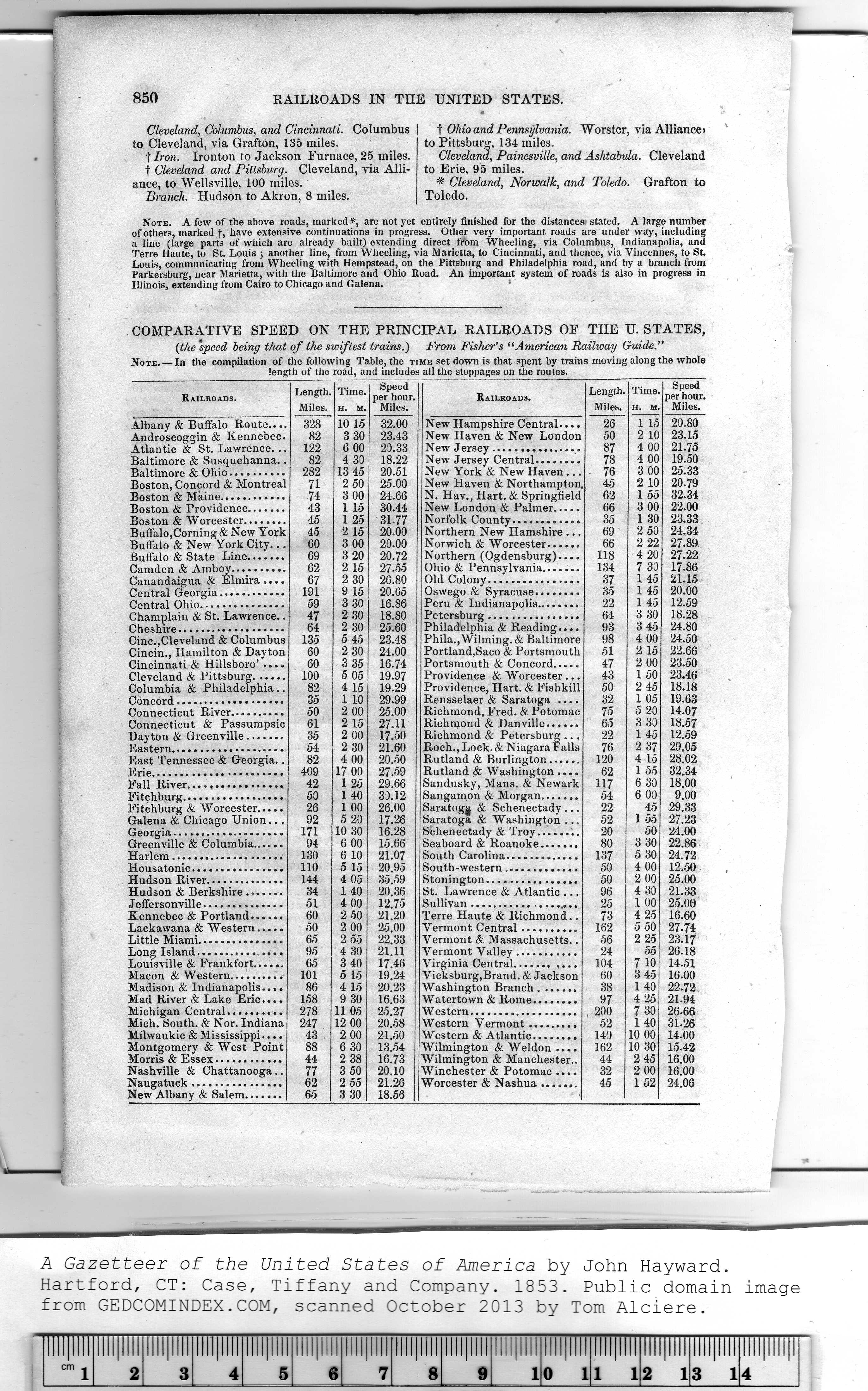
|
Railroads. |
Length.
Miles. |
Time.
H. M. |
Speed
per hour.
Miles. |
Railroads. |
Length.
Miles. |
Time
H. M |
Speed
per hour.
Miles. |
|
Albany & Buffalo Route.... |
328 |
10 15 |
32.00 |
New Hampshire Central.... |
26 |
1 15 |
20.80 |
|
Androscoggin & Kennebec. |
82 |
3 30 |
23.43 |
New Haven & New London |
50 |
2 10 |
23.15 |
|
Atlantic & St. Lawrence... |
122 |
6 00 |
20.33 |
New Jersey................ |
87 |
4 00 |
21.75 |
|
Baltimore & Susquehanna.. |
82 |
4 30 |
18.22 |
New Jersey Central........ |
78 |
4 00 |
19.50 |
|
Baltimore & Ohio.......... |
282 |
13 45 |
20.51 |
New York & New Haven... |
76 |
3 00 |
25.33 |
|
Boston, Concord & Montreal |
71 |
2 50 |
25.00 |
New Haven & Northampton, |
45 |
2 10 |
20-79 |
|
Boston & Maine............ |
74 |
3 00 |
24.66 |
N. Hav., Hart. & Springfield |
62 |
1 55 |
32.34 |
|
Boston & Providence....... |
43 |
1 15 |
30.44 |
New London & Palmer..... |
66 |
3 00 |
22.00 |
|
Boston & Worcester........ |
45 |
1 25 |
31-77 |
Norfolk County............ |
35 |
1 30 |
23.33 |
|
Buffalo,Corning & New York |
45 |
2 15 |
20.00 |
Northern New Hamshire ... |
69 |
2 50 |
24.34 |
|
Buffalo & New York City... |
60 |
3 00 |
20.00 |
Norwich & Worcester...... |
66 |
2 22 |
27.89 |
|
Buffalo & State Line....... |
69 |
3 20 |
20.72 |
Northern (Ogdensburg).... |
118 |
4 20 |
27.22 |
|
Camden & Amboy.........
Canandaigua & Elmira .... |
62
67 |
2 15
2 30 |
27.55
26.80 |
Ohio & Pennsylvania.......
Old Colony................ |
134
37 |
7 30
1 45 |
17.86
21.15 |
|
Central Georgia............
Central Ohio............... |
191
59 |
9 15
3 30 |
20.65
16.86 |
Oswego & Syracuse........
Peru & Indianapolis........ |
35
22 |
1 45
1 45 |
20.00
12.59 |
|
Champlain & St. Lawrence.. |
47 |
2 30 |
18.80 |
Petersburg................ |
64 |
3 30 |
18.28 |
|
Cheshire................... |
64 |
2 30 |
25.60 |
Philadelphia & Reading.... |
93 |
3 45 |
24.80 |
|
Cine.,Cleveland & Columbus |
135 |
5 45 |
23.48 |
Phila.,Wilming.& Baltimore |
98 |
4 00 |
24.50 |
|
Cincin., Hamilton & Dayton
Cincinnati & Hillsboro' .... |
60 |
2 30 |
24.00 |
Portland,Saco & Portsmouth |
51 |
2 15 |
22.66 |
|
60 |
3 35 |
16.74 |
Portsmouth & Concord..... |
47 |
2 00 |
23.50 |
|
Cleveland & Pittsburg...... |
100 |
5 05 |
19.97 |
Providence & Worcester... |
43 |
1 50 |
23.46 |
|
Columbia & Philadelphia.. |
82 |
4 15 |
19.29 |
Providence, Hart. & Fishkill |
50 |
2 45 |
18.18 |
|
Concord................... |
35 |
1 10 |
29.99 |
Rensselaer & Saratoga .... |
32 |
1 05 |
19.63 |
|
Connecticut River.......... |
50 |
2 00 |
25.00 |
Richmond, Fred. & Potomac |
75 |
5 20 |
14.07 |
|
Connecticut & Passumpsie |
61 |
2 15 |
27.11 |
Richmond & Danville...... |
65 |
3 30 |
18.57 |
|
Dayton & Greenville....... |
35 |
2 00 |
17.50 |
Richmond & Petersburg ... |
22 |
1 45 |
12.59 |
|
Eastern.................... |
54 |
2 30 |
21.60 |
Roch., Lock. & Niagara Falls |
76 |
2 37 |
29.05 |
|
East Tennessee & Georgia.. |
82 |
4 00 |
20.50 |
Rutland & Burlington...... |
120 |
4 15 |
28.02 |
|
Erie....................... |
409 |
17 00 |
27.59 |
Rutland & Washington .... |
62 |
1 55 |
32.34 |
|
Fall River....,............ |
42 |
1 25 |
29.66 |
Sandusky, Mans. & Newark |
117 |
6 30 |
18.00 |
|
Fitchburg.................. |
50 |
1 40 |
30.12 |
Sangamon & Morgan....... |
54 |
6 00 |
9.00 |
|
Fitchburg & Worcester..... |
26 |
1 00 |
26.00 |
Saratoga & Schenectady... |
22 |
45 |
29.33 |
|
Galena & Chicago Union... |
92 |
5 20 |
17.26 |
Saratoga & Washington ... |
52 |
1 55 |
27.23 |
|
|
171
94 |
10 30 |
16 28 |
|
20
80 |
50
3 30 |
24.00
22.86
24.72
12.50
25.00
21.33 |
|
|
6 00 |
15.66 |
|
|
|
130 |
6 10 |
21.07
20.95
35.59
20.36 |
|
137
50
50 |
5 30
4 00 |
|
|
no |
5 15 |
|
|
|
144 |
4 05 |
|
2 00 |
|
Hudson & Berkshire....... |
34 |
1 40 |
St. Lawrence & Atlantic ... |
96 |
4 30 |
|
|
51 |
4 00 |
12.75
21.20 |
|
25
73 |
1 00 |
25.00
16.60 |
|
Kennebec & Portland...... |
60 |
2 50 |
Terre Haute & Richmond.. |
4 25 |
|
Lackawana & Western..... |
50 |
2 00 |
25.00 |
Vermont Central.......... |
162 |
5 50 |
27-74 |
|
Little Miami............... |
65 |
2 55 |
22.33 |
Vermont & Massachusetts.. |
56 |
2 25 |
23.17 |
|
|
|
4 30 |
21.11
17.46 |
|
24
104 |
55
7 10 |
26.18
14.51 |
|
Louisville & Frankfort...... |
65 |
3 40 |
Virginia Central........... |
|
Macon & Western.......... |
101 |
5 15 |
19.24 |
Vicksburg,Brand. & Jackson |
60 |
3 45 |
16.00 |
|
Madison & Indianapolis.... |
86 |
4 15 |
20.23 |
Washington Branch....... |
38 |
1 40 |
22.72 |
|
Mad River & Lake Erie.... |
158 |
9 30 |
16.63 |
Watertown & Rome........ |
97 |
4 25 |
21.94 |
|
Michigan Central.......... |
278 |
11 05 |
25.27 |
Western................... |
200 |
7 30 |
26-66 |
|
Mich. South. & Nor. Indiana |
247 |
12 00 |
20.58 |
Western Vermont......... |
52 |
1 40 |
31.26 |
|
Milwaukie & Mississippi.... |
43 |
2 00 |
21.50 |
Western & Atlantic........ |
140 |
10 00 |
14.00 |
|
Montgomery & West Point |
88 |
6 30 |
13.54 |
Wilmington & Weldon .... |
162 |
10 30 |
15.42 |
|
Morris & Essex............ |
44 |
2 38 |
16.73 |
Wilmington & Manchester.. |
44 |
2 45 |
16.00 |
|
Nashville & Chattanooga.. |
77 |
3 50 |
20.10 |
Winchester & Potomac .... |
32 |
2 00 |
16.00 |
|
Naugatuck................ |
62 |
2 55 |
21.26 |
Worcester & Nashua....... |
45 |
1 52 |
24.06 |
|
New Albany & Salem....... |
65 |
3 30 |
18.56 | |
|
|
|