|
Gazetteer of the State of Maine With Numerous Illustrations, by Geo. J. Varney
BOSTON: PUBLISHED BY B. B. RUSSELL, 57 CORNHILL. 1882. Public domain image from
THE STATE OF MAINE. 15
|
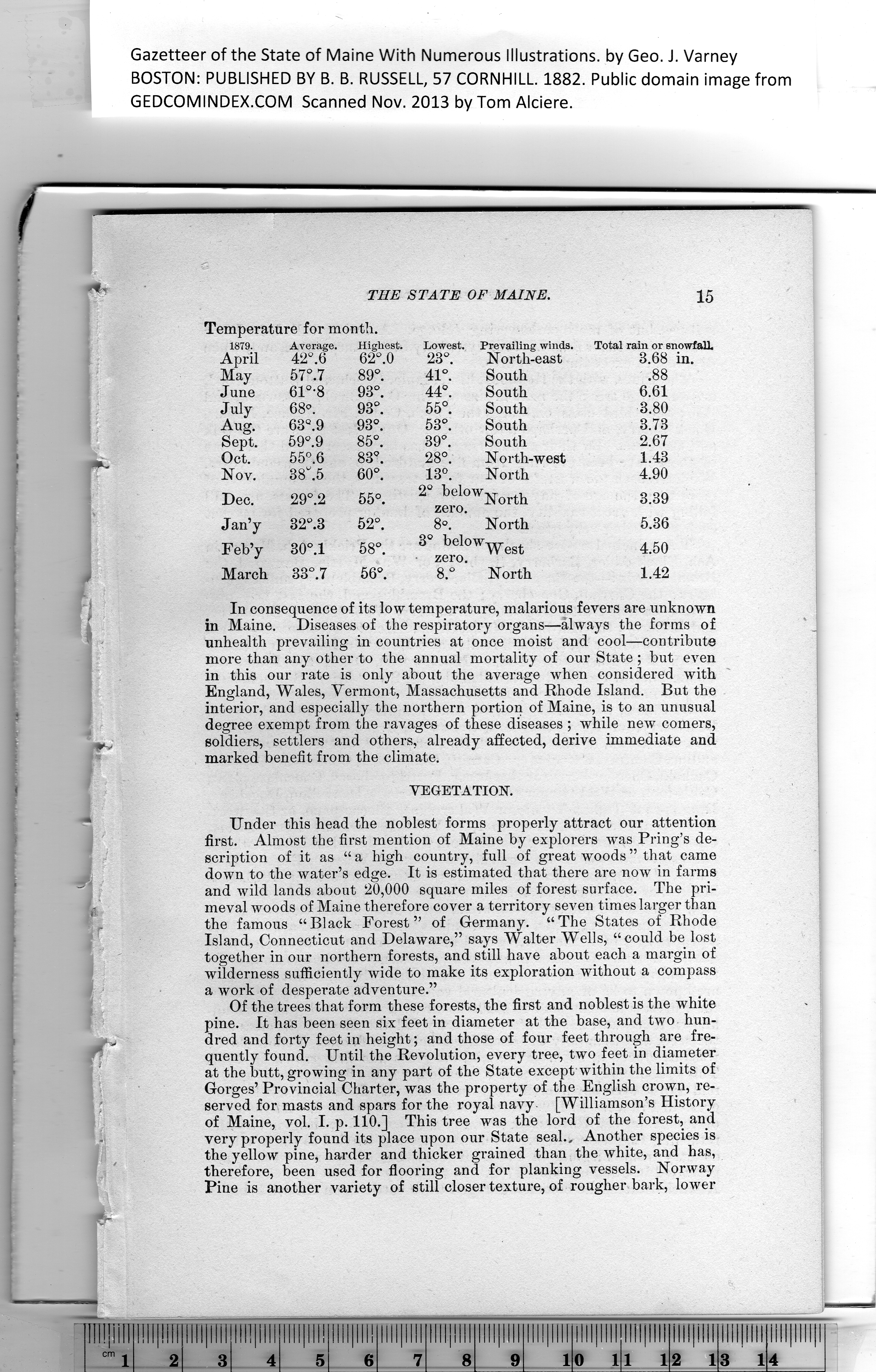
Temperature for month. |
|
1879.
April |
Average.
42°. 6 |
Highest.
62°.0 |
Lowest.
23°. |
Prevailing winds.
North-east |
Total rain or snowfall
3.68 in. |
|
May |
57°.7 |
89°. |
41°. |
South |
.88 |
|
June |
61°-8 |
93°. |
44°. |
South |
6.61 |
|
July |
68°. |
93°. |
55°. |
South |
3.80 |
|
Aug. |
63Q.9 |
93°. |
53°. |
South |
3.73 |
|
Sept. |
59°.9 |
85°. |
39°. |
South |
2.67 |
|
Oct. |
55°.6 |
83°. |
28°. |
North-west |
1.43 |
|
Nov. |
38h5 |
60°. |
13°. |
North |
4.90 |
|
Dec. |
29°.2 |
55°. |
2° helowNorth
zero. |
3.39 |
|
Jan’y |
32°.3 |
52°. |
8°. |
North |
5.36 |
|
Feb’y |
30°.l |
58°. |
3° belowWest
• zero. |
4.50 |
|
March |
33°.7 |
56°. |
8.° |
North |
1.42 |
|
In consequence of its low temperature, malarious fevers are unknown
in Maine. Diseases of the respiratory organs—always the forms of
unhealth prevailing in countries at once moist and cool—contribute
more than any other to the annual mortality of our State ; but even
in this our rate is only about the average when considered with
England, Wales, Vermont, Massachusetts and Rhode Island. But the
interior, and especially the northern portion of Maine, is to an unusual
degree exempt from the ravages of these diseases ; while new comers,
soldiers, settlers and others, already affected, derive immediate and
marked benefit from the climate.
VEGETATION.
Under this head the noblest forms properly attract our attention
first. Almost the first mention of Maine by explorers wTas Pring’s de-
scription of it as “ a high country, full of great woods ” that came
down to the water’s edge. It is estimated that there are now in farms
and wild lands about 20,000 square miles of forest surface. The pri-
meval woods of Maine therefore cover a territory seven times larger than
the famous “Black Forest” of Germany. “The States of Rhode
Island, Connecticut and Delaware,” says Walter Wells, “could be lost
together in our northern forests, and still have about each a margin of
wilderness sufficiently wide to make its exploration without a compass
a work of desperate adventure.”
Of the trees that form these forests, the first and noblest is the white
pine. It has been seen six feet in diameter at tbe base, and two hun-
dred and forty feet in height; and tbose of four feet through are fre-
quently found. Until the Revolution, every tree, two feet in diameter
at tbe butt, growing in any part of the State except within the limits of
Gorges’ Provincial Charter, was the property of the English crown, re-
served for masts and spars for the royal navy [Williamson’s History
of Maine, vol. I. p. 110.] This tree was the lord of the forest, and
very properly found its place upon our State seal.. Another species is
the yellow pine, harder and thicker grained than the white, and has,
therefore, been used for flooring and for planking vessels. Norway
Pine is another variety of still closer texture, of rougher bark, lower
PREVIOUS PAGE ... NEXT PAGE
This page was written in HTML using a program written in Python 3.2
|