|
TOPOGRAPHY.
Surface.—This State lies upon that portion of the Appalachian Mountain system where the
mountains generally assume the character of hills and finally sink to a level of the lowlands that
surround the great depression filled by Lake Ontario and the St. Lawrence River. Three distinct
mountain masses or ranges enter the State from the s. and extend across it in a general n. e. direc¬
tion. The first or most easterly of these ranges—a continuation of the Blue Ridge of Ya.-—enters
the State from N. J. and extends n. e. through Rockland and Orange cos. to the Hudson, appears
on the e. side of that river, and forms the highlands of Putnam and Dutchess cos. A northerly
extension of the same range passes into the Green Mts. of Western Mass. and Vt. This range
culminates in the Highlands upon the Hudson. The highest peaks are 1,000 to 1,700 feet above
tide. The rocks which compose these mountains are principally primitive or igneous, and the
mountains themselves are rough, rocky, and precipitous, and unfit for cultivation. The deep
gorge formed by the Hudson in passing through this range presents some of the finest scenery in
America, and has often been compared to the celebrated valley of the Rhine.
The second series of mountains enters the State from Penn, and extends sr. e. through Sullivan,
Ulster, and Greene cos., terminating and culminating in the Catskill Mts. upon the Hudson.
The highest peaks are 3,000 to 3,800 feet above tide. The Shawangunk Mts., a high and con¬
tinuous ridge extending between Sullivan and Orange cos. and into the s. part of Ulster, is the
extreme e. range of this series. Tjie Helderbergh and Hellibark Mts. are spurs extending n.
from the main range into Albany and Schoharie cos. This whole mountain system is principally
composed of the rocks of the New York system above the Medina sandstone. • The summits are
generally crowned with old red sandstone and with the conglomerate of the coal measures. The
declivities are steep and rocky; and a large share of the surface is too rough for cultivation. The
highest peaks overlook the Hudson, and from their summits are obtained some of the finest views
in Eastern New York.
The third series of mountains enters the State from Penn, and extends n. e. through Broome,
Delaware, Otsego, Schoharie, Montgomery, and Herkimer cos. to the Mohawk, appears upon the
n. side of that river, and extends n. e., forming the whole series of highlands that occupy the n. e.
part of the State and generally known as the Adirondack Mountain region. South of the Mohawk
this mountain system assumes the form of broa,d, irregular hills, occupying a wide space of country.
It is broken by the deep ravines of the streams, and in many places the hills are steep and nearly
precipitous. The valley of the Mohawk breaks the* continuity of the range, though the connec¬
tion is easily traced at Little Falls, The Noses, and other places. North of the Mohawk the high¬
lands extend n. e. in several distinct ranges, all terminating upon Lake Champlain. The cul¬
minating point of the whole system, and the highest mountain in the State, is Mt. Marcy, 5,467
feet above tide. The rocks of all this region are principally of igneous origin, and the mountains
are usually wild, rugged, and rocky. A large share of the surface is entirely unfit for cultiva¬
tion; but the region is rich in minerals, and especially in an excellent variety of iron ore. West
of these ranges, series of hills forming spurs of the Alleganies enter the State from Penn, and
occupy the entire s. half of the w. part of the State. An irregular line ‘extending through the
southerly counties forms the watershed that separates the northern and southern drainage; and
from it the surface gradually declines northward until it finally terminates in the level of Lake
Ontario.1 The portion of the State lying s. of this watershed and occupying the greater part of
|
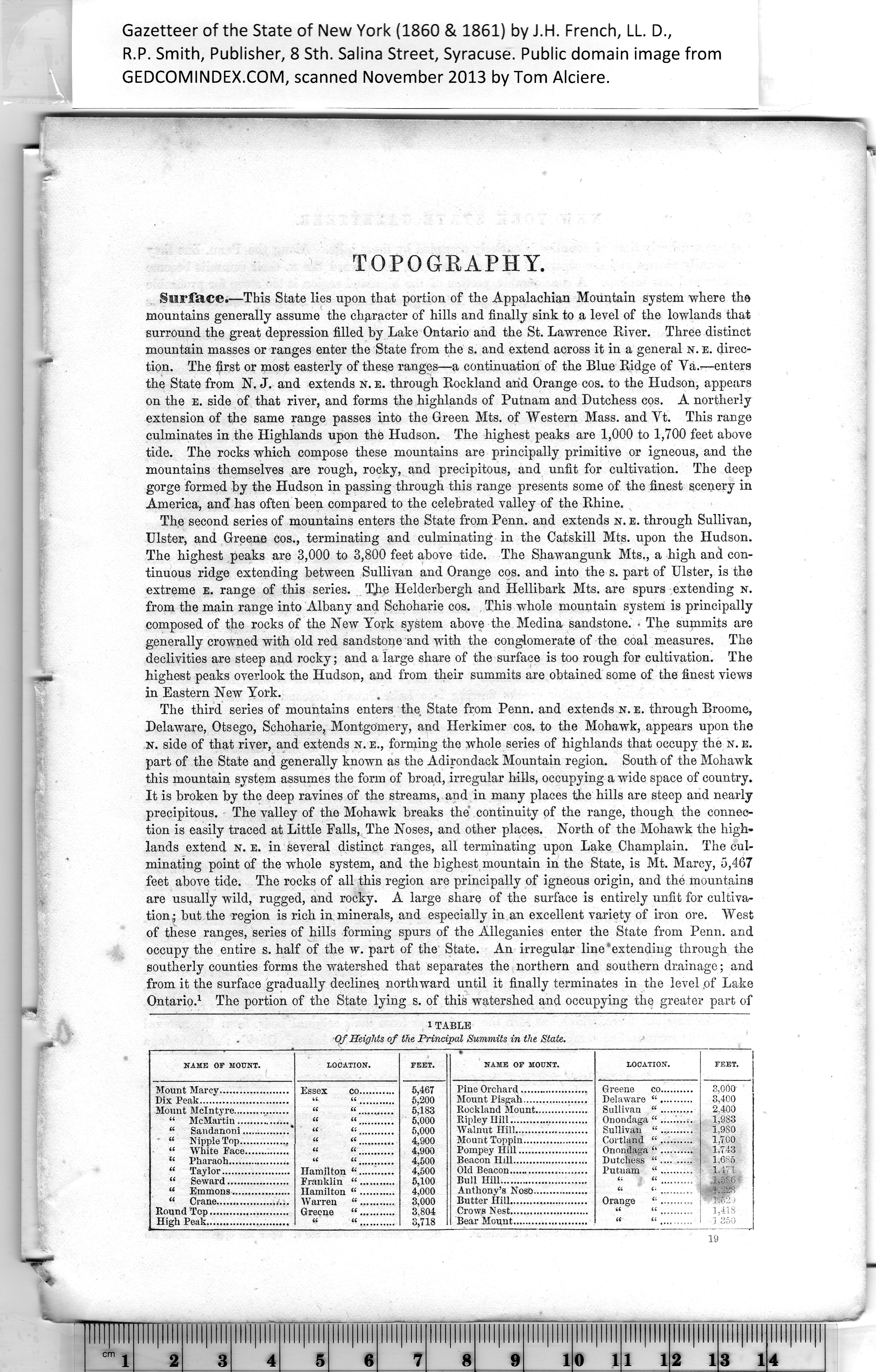
iTABLE
Of Heights of the Principal Summits in the State. |
|
NAME OF MOUNT. |
LOCATION. |
FEET. |
NAME OP MOUNT. |
LOCATION. |
PEET. |
|
Mount Marcy..................... |
Essex co........... |
5,467
5,200
5,183
5.000
5.000
4.900
4.900
4.500
4.500
5,100
4.000
3.000
3,804
3,718 |
Pine Orchard..................... |
Greene co.......... |
3.000
3.400
2.400
1,983
1,980
1,700
1.743
1,685
1,171
.1,586
j,22S
1.418
] 350 |
|
Mount McIntyre.................
“ McMartin................
“ Sandanoni...............
‘ u Nipple Top...............
ft White Face..............
u Pharaoh................... |
i( a
u a
u <(
(( a |
Rockland Mount..........i.....
Ripley Hill........................
Walnut Hill......................
Mount Toppin....................
Pompey Hill.....................
Beacon Hill....................... |
Sullivan “..........
Onondaga “..........
Sullivan “..........
Cortland “..........
Onondaga “ ..........
Dutchess “......... |
|
|
|
Bull Hill........................... |
|
|
“ Emmons.................. |
Hamilton “........... |
Anthony’s Noso................. |
|
|
|
|
|
|
|
High Peak......................... |
|
Bear Mount....................... |
“ |
|
|