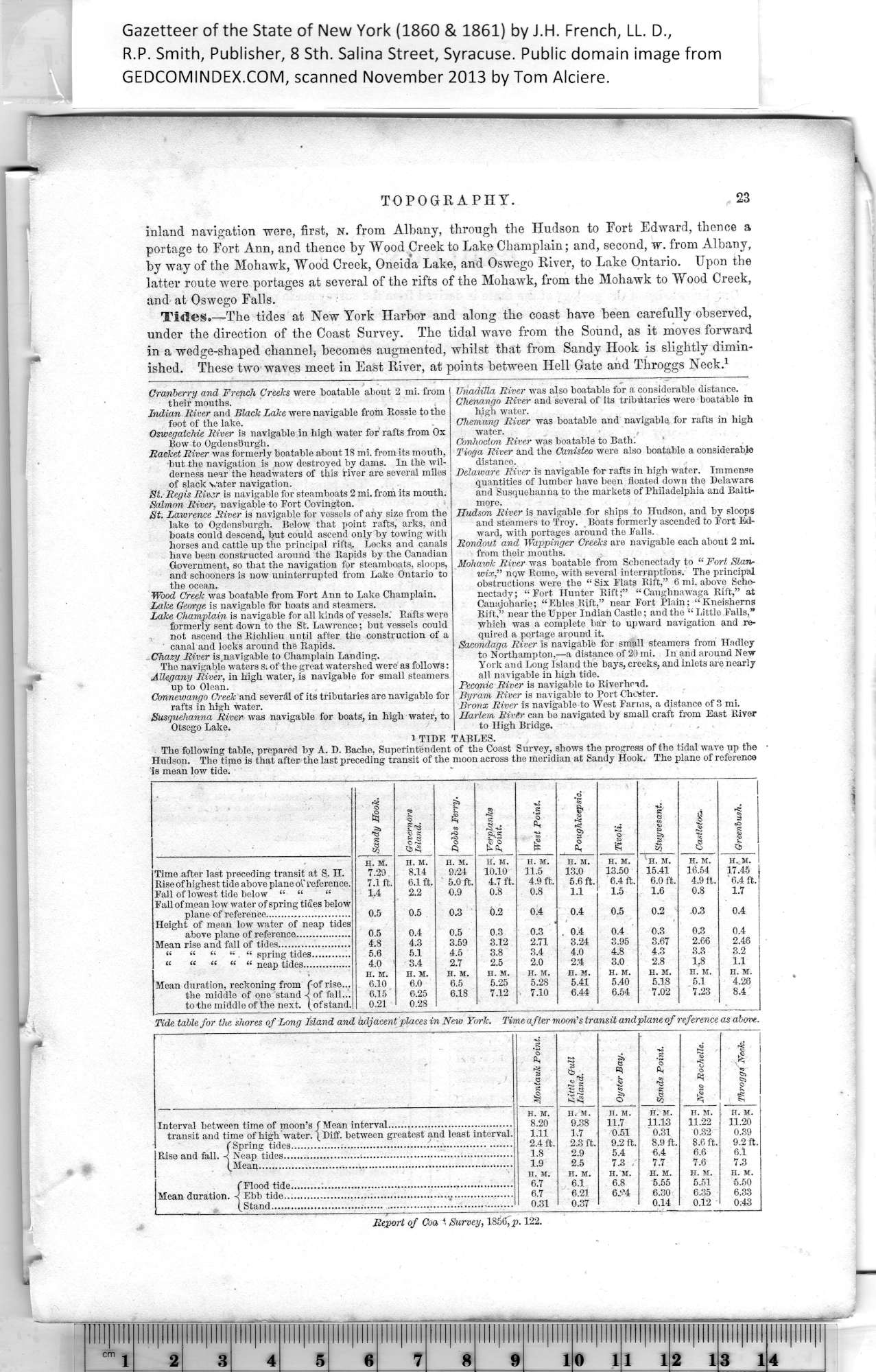
Gazetteer of New York, 1860 & 1861 page 023
Click on the image to view a larger, bitmap (.bmp) image suitable for printing.

HOME PAGE ... REFERENCE PAGE ... THIS GAZETTEER’S PAGE


Click on the image above for a larger, bitmap image suitable for printing.

TOPOGRAPHY.

inland navigation were, first, n. from Albany, through the Hudson to Fort Edward, thence a
portage to Fort Ann, and thence by Wood Creek to Lake Champlain; and, second, w. from Albany,
by way of the Mohawk, Wood Creek, Oneida Lake, and Oswego River, to Lake Ontario. Upon the
latter route were portages at several of the rifts of the Mohawk, from the Mohawk to Wood Creek,
and at Oswego Falls.

23


Tides.—The tides at New York Harbor and along the coast have been carefully observed,
under the direction of the Coast Survey. The tidal wave from the Sound, as it moves forward
in a wedge-shaped channel, becomes augmented, whilst that from Sandy Hook is slightly dimin¬
ished. These two waves meet in East River, at points between Hell Gate and Throggs Neck
.1

Cranberry and French Creeks were boatable about 2 mi. from
their mouths.

Indian River and Black Lake were navigable from Rossie to the
foot of the lake.

Oswegatchie River is navigable in high water for rafts from Ox
Bow to Ogden sburgh.

Racket River was formerly boatable about 18 mi. from its mouth,
but the navigation is now destroyed by dams. In the wil¬
derness near the headwaters of this river are several miles
of slack vater navigation.

St. Regis River is navigable for steamboats 2 mi. from its mouth.

Salmon River, navigable to Fort Covington.

St. Lawrence River is navigable for vessels of any size from the
lake to Ogdensburgh. Below that point rafts, arks, and
boats could descend, but could ascend only by towing with
horses and cattle up the principal rifts. Locks and canals
have been constructed around the Rapids by the Canadian
Government, so that the navigation for steamboats, sloops,
and schooners is now uninterrupted from Lake Ontario to
the ocean.

Wood Creek was boatable from Fort Ann to Lake Champlain.

Lake George is navigable for boats and steamers.

Lake Champlain is navigable for all kinds of vessels. Rafts were
formerly sent down to the St. Lawrence; but vessels could
not ascend theRichlieu until after the construction of a
canal and locks around the Rapids.

_ Chazy River is.navigable to Champlain Landing.

The navigable waters S; of the great watershed were as follows:

Allegany River, in high water, is navigable for small steamers
up to Olean.

Conneviango Creek and several of its tributaries are navigable for
rafts in high water.

Susquehanna River was navigable for boats, in high water, to
Otsego Lake.

XTnadilla River was also boatable for a considerable distance.

Chenango River and several of its tributaries were boatable in
high water.

Chemung River was boatable and navigable for rafts in high
water.    ,

Conhocton River was boatable to Bath;

Tioga River and the Canisteo were also boatable a considerable
distance.

Delaware River is navigable for rafts in high water. Immense
quantities of lumber have been floated down the Delaware
and Susquehanna to the markets of Philadelphia and Balti¬
more.

Hudson River is navigable for ships to Hudson, and by sloops
and steamers to Troy. Boats formerly ascended to Fort Ed¬
ward, with portages around the Falls.

Rondout and Wappinger Creeks are navigable each about 2 mi
from their mouths.

Mohav)k River was boatable from Schenectady to “Fort Stan-
wix
,” nqw Rome, with several interruptions. The principal
obstructions were the “ Six Flats Rift,” 6 mi. above Sche¬
nectady; “Fort Hunter Rift;” “Caughnawaga Rift,” at
Canajoharie; “Ehles Rift,” near Fort Plain; “Kneisherns
Rift,” near the Upper Indian Castle; and the “ Little Falls,”
which was a complete bar to upward navigation and re¬
quired a portage around it.

Sacondaga River is navigable for small steamers from Hadley
to Northampton,—a distance of 20 mi. In and around New
York and Long Island the bays, creeks, and inlets are nearly
all navigable in high tide.

Peconie River is navigable to Riverhcid.

Byram River is navigable to Port Chester.

Bronx River is navigable to West Farms, a distance of 3 mi.

Harlem River can be navigated by small craft from East River
to High Bridge.


1 TIDE TABLES.

The following table, prepared by A. D. Bache, Superintendent of the Coast Survey, shows the progress of the tidal wave up the
Hudson. The time is that after the last preceding transit of the moon across the meridian at Sandy Hook. The plane of reference
is mean low tide.

Sandy Hook.

Governors

\lsland.

Dobbs Ferry.

t Verplanks
1 Point.

West Point.

1

•3

-e;

&

o

o

'1

Stuyvesant.

1

1

<

3

A

s

s

ts

H. M.

H. M.

H. M.

H. M.

H. M.

H. M.

H. M.

H. M.

H. M.

H. M.

Time after last preceding transit at S. II.

7.29

8.14

9.24

10.10

11.5

13.0

13.50

15.41

16.54

17.45

Rise of highest tide above plane of reference.

7.1 ft.

6.1 ft.

5.0 ft.

4.7 ft.

4.9 ft.

5.6 ft.

6.4 ft.

6.0 ft.

4.9 it.

6.4 ft.

Fall of lowest tide below “ “

1.4

2.2

0.9

0.8

0.8

1.1

1.5

1.6

0.8

1.7

Fall of mean low water of spring tides below

0.4

0.4

0.5

0.2

0.3

0.4

plane of reference..........................

0.5

0.5

0.3

0.2

Height of mean low water of neap tides

above plane of reference.................

0.5

0.4

0.5

0.3

0.3

. 0.4

0.4

0.3

0.3

0.4

Mean rise and fall of tides......................

4.8

4.3

3.59

3.12

2.71

3.24

3.95

3.67

2.66

2.46

“ “ “ “ spring tides............

5.6

5.1

4.5

3.8

3.4

4.0

4.8

4.3

3.3

3.2

“ “ “ “ “ neap tides...............

4.0

3.4

2.7

2.5

2.0

2:4

3.0

2.8

1.8

1.1

H. M.

H. M.

H. M.

H. M.

H. M.

H. M.

H. M.

H. M.

H. M.

H. M.

Mean duration, reckoning from (of rise...

6.10

6.0

6.5

5.25

5.28

5.41

5.40

5.18

5.1

4.26

the middle of one stand -c of fall...
to the middle of the next, (of stand.

6.15

0.21

6.25

0.28

6.18

7.12

7.10

6.44

6.54

7.02

7.23

8.4

Tide table for the shores of Long Island and adjacent places in New York. Time after moon's transit andplane of reference as above.

i

Montauh Point.

Little Gull
Island.

Oyster Bay.

Sands Point.

New Rochelle.

.1

§i

p

g

H. M.

H. M.

H. M.

H. M.

H. M.

n. m.

Interval between time of moon’s I Mean interval......................................

8.20

9.38

11.7

11.13

11.22

11.20

transit and time of high water. (Diff. between greatest and least interval.

1.11

1.7

0.51

0.31

0.32

0.39

( Spring tides..................................................................

2.4 ft.

2.3 ft.

9.2 ft.

8.9 ft.

8.6 ft.

9.2 ft.

Rise and fall. -J Neap tides.....................................................................

1.8

2.9

5.4

6.4

6.6

6.1

(Mean.............................................................................

1.9

2.5

7.3

7.7

7.6

7.3

H. M.

H. M.

H. M.

H. M.

H. M.

H. M.

(Flood tide..................................................-................

6.7

6.1

6.8

5.55

5.51

5.50

Mean duration. -< Ebb tide.....................................................................

6.7

6.21

6„"4

6.30

6.35

6.33

(Stand........................................................................

0.31

0.37

0.14

0.12

0.43

Report of Coa *■ Survey, 1856, jj. 122.


PREVIOUS PAGE ... NEXT PAGE

This page was written in HTML using a program written in Python 3.2