|
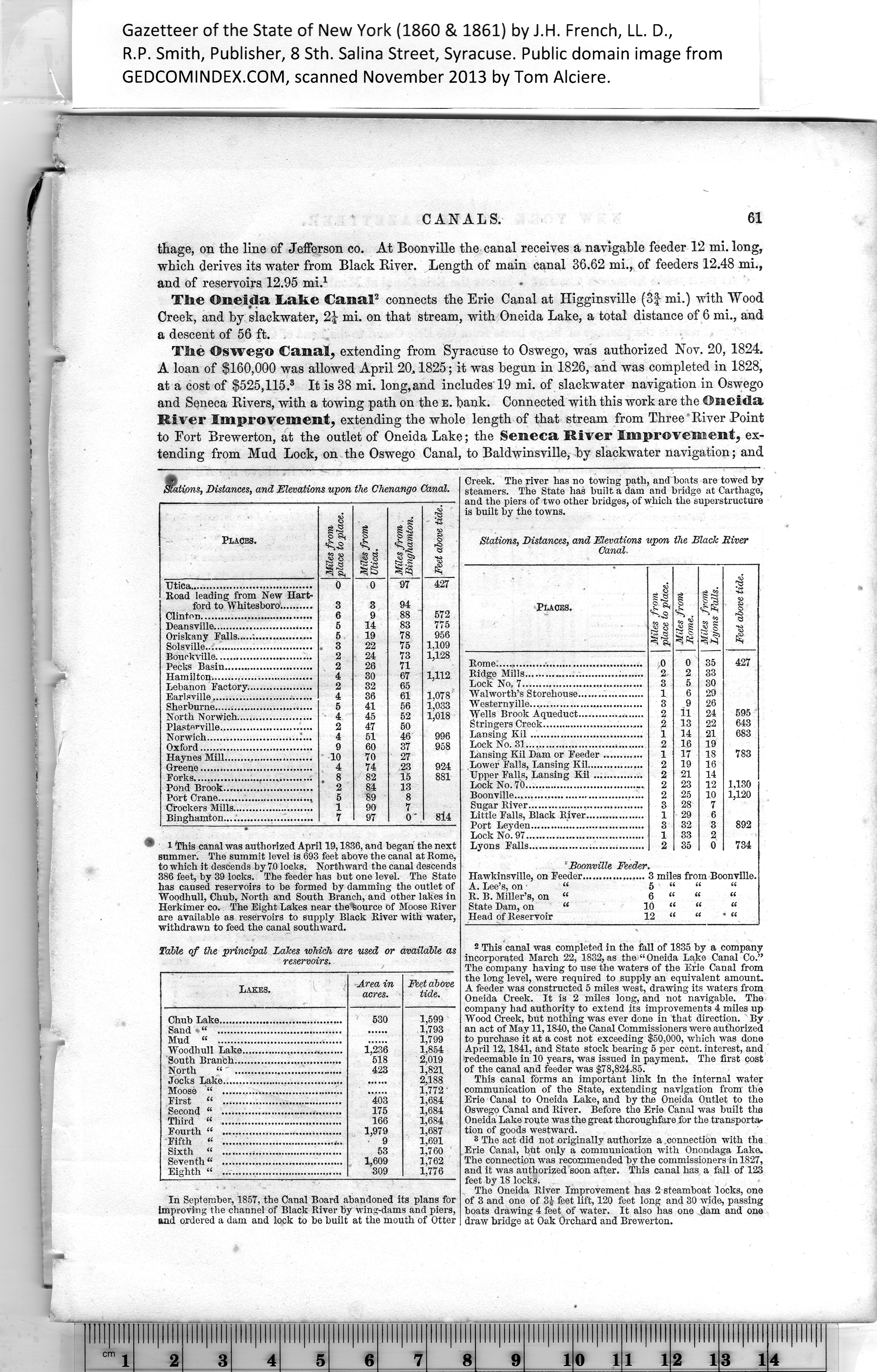
'ions, Distances, and Elevations upon the Chenango Canal. |
|
Places. |
Miles from
place to place. |
Miles from
Ctica. |
Miles from
Binghamton. |
Feet above tide. |
|
Utica.....................................
Road leading from New Hart¬ |
0 |
0 |
97 |
427 |
|
ford to Whitesboro.......... |
3 |
3 |
94 |
|
|
Clinton.................................. |
6 |
9 |
88 |
572 |
|
Deansville.............................. |
5 |
14 |
83 |
775 |
|
Oriskany Falls.....;................. |
5 |
19 |
78 |
956 |
|
Solsville................................. |
. 3 |
22 |
75 |
1,109 |
|
Bouokville............................. |
2 |
24 |
73 |
1,128 |
|
Pecks Basin........................... |
2 |
26 |
71 |
|
|
Hamilton............................... |
4 |
30 |
67 |
1,112 |
|
Lebanon Factory.................... |
2 |
32 |
65 |
1,078 |
|
Earlsville.............................. |
4 |
36 |
61 |
|
Sherburne.............................. |
5 |
41 |
56 |
1,033 |
|
North Norwich....................... |
4 |
45 |
52 |
1,018 |
|
Plasterville............................ |
2 |
47 |
50 |
|
|
Norwich......................... |
4 |
51 |
46 |
996 |
|
Oxford.................................. |
9 |
60 |
37 |
958 |
|
Haynes Mill........................... |
10 |
70 |
27 |
|
|
Greene.................................. |
4 |
74 |
23 |
924 |
|
Forks.................................... |
, 8 |
82 |
15 |
881 |
|
Pond Brook........................... |
2 |
84 |
13 |
|
|
Port Crane............................, |
5 |
89 |
8 |
|
|
Crockers Mills......................... |
1 |
90 |
7 |
8l4 |
|
Binghamton........................... |
7 |
97 |
0' |
|
' 1 This canal was authorized April 19,1836, and began the next
summer. The summit level is 693 feet above the canal at Rome,
to which it descends by 70 locks. Northward the canal descends
386 feet, by 39 locks. The feeder has but one level. The State
has caused reservoirs to be formed by damming the outlet of
Woodhull, Chub, North and South Branch, and other lakes in
Herkimer co. The Eight Lakes near the%ource of Moose River
are available as reservoirs to supply Black River with water,
withdrawn to feed the canal southward.
Table of the principal Lakes which are used or available as
reservoirs.
Area in Feet above
acres. tide.
1,599
1,793
1,799
1,854
2,019
1,821
2,188
1,772 ’
1.684
1.684
1.684
1,687
1,691
1,760
1,762
1.776
Chub Lake........
Sand • “ ........
Mud “ ........
Woodhull Lake,
South Branch...
North «' ...
Jocks Lake.......
Moose “ .......
First “ .......
Second “ .......
Third “ .......
Fourth “ .......
Fifth « .......
Sixth “ .......
Seventh<! .......
Eighth “ .......
In September, 1857, the Canal Board abandoned its plans for
Improving the channel of Black River by wing-dams and piers,
and ordered a dam and lock to be built at the mouth of Otter |
Creek. The river has no towing path, and boats are towed by
steamers, l'he State has built a dam and bridge at Carthage,
and the piers of two other bridges, of which the superstructure
is built by the towns.
Stations, Distances, and Elevations upon the Black River
Canal.
|
Places. |
Miles from
place to place. |
1 Miles from
1 Rome. |
i Miles from,
| Lyons Falls. ] |
Feet above tide. |
|
Rome...............■............................. |
0 |
0 |
35 |
427 |
|
Ridge Mills.................................... |
2 |
2 |
33 |
|
|
Lock No, 7.................................... |
3 |
5 |
30 |
|
|
Walworth’s Storehouse.................... |
1 |
6 |
29 |
|
|
Western ville.................................. |
3 |
9 |
26 |
|
|
Wells Brook Aqueduct.................... |
2 |
11 |
24 |
595 |
|
Stringers Creek............................... |
2 |
13 |
22 |
643 |
|
Lansing Kil .................................. |
1 |
14 |
21 |
683 |
|
Lock No. 31.................................... |
2 |
16 |
19 |
|
|
Lansing Kil Dam or Feeder ............ |
1 |
17 |
18 |
783 |
|
Lower Falls, Lansing Kil.................
Upper Falls, Lansing Kil ............... |
2 |
19 |
16 |
|
|
2 |
21 |
14 |
|
|
Lock No. 70.................................... |
2 |
23 |
12 |
1,130 |
|
Boonville....................................... |
2 |
25 |
10 |
1,120 |
|
Sugar River................................... |
3 |
28 |
7 |
|
Little Falls, Black River.................. |
1 |
29 |
6 |
|
|
Port Leyden................................... |
3 |
32 |
3 |
892 |
|
Lock No. 97.................................... |
1 |
33 |
2 |
|
|
Lyons Falls...................................
‘ Boonville Feeder |
2 |
35 |
0 |
734 |
|
Hawkinsville, on Feeder................... |
3 miles from Boonville. |
|
A. Lee’s, on “ |
5 ‘ |
|
|
|
|
R. B. Miller’s, on “ |
6 “ ‘ |
|
ct |
|
State Dam, on “ 10 “ ‘ |
|
« |
|
Head of Reservoir 12 * |
u |
i: |
2 This canal was completed in the fall of 1835 by a company
incorporated March 22, 1832, as the “Oneida Lake Canal Co.”
The company having to use the waters of the Erie Canal from
the long level, were required to supply an equivalent amount.
A feeder was constructed 5 miles west, drawing its waters from
Oneida Creek. It is 2 miles long, and not navigable. The
company had authority to extend its improvements 4 miles up
Wood Creek, but nothing was ever done in that direction. By
an act of May 11,1840, the Canal Commissioners were authorized
to purchase it at a cost not exceeding $50,000, which was done
April 12,1841, and State stock bearing 5 per cent, interest, and
redeemable in 10 years, was issued in payment. The first cost
of the canal and feeder was $78,824.85.
This canal forms an important link in the internal water
communication of the State, extending navigation from the
Erie Canal to Oneida Lake, and by the Oneida Outlet to the
Oswego Canal and River. Before the Erie Canal was built the
Oneida Lake route was the great thoroughfare for the transportar
tion of goods westward.
8 The act did not originally authorize a .connection with the
Erie Canal, but only a communication with Onondaga Lake.
The connection was recommended by the commissioners in 1827,
and it was authorized soon after. This canal has a fall of 123
feet by 18 locks.
The Oneida River Improvement has 2 steamboat locks, one
of 3 and one of 3i feet lift, 120 feet long and 30 wide, passing
boats drawing 4 feet of water. It also has one dam and one
draw bridge at Oak Orchard and Brewerton. |