Gazetteer of New York, 1860 & 1861 page 064
Click on the image to view a larger, bitmap (.bmp) image suitable for printing.

HOME PAGE ... REFERENCE PAGE ... THIS GAZETTEER’S PAGE


Click on the image above for a larger, bitmap image suitable for printing.

64    NEW    YORK    STATE    GAZETTEER.

Distances on the Delaware and Hudson Canal.

Names op Places.

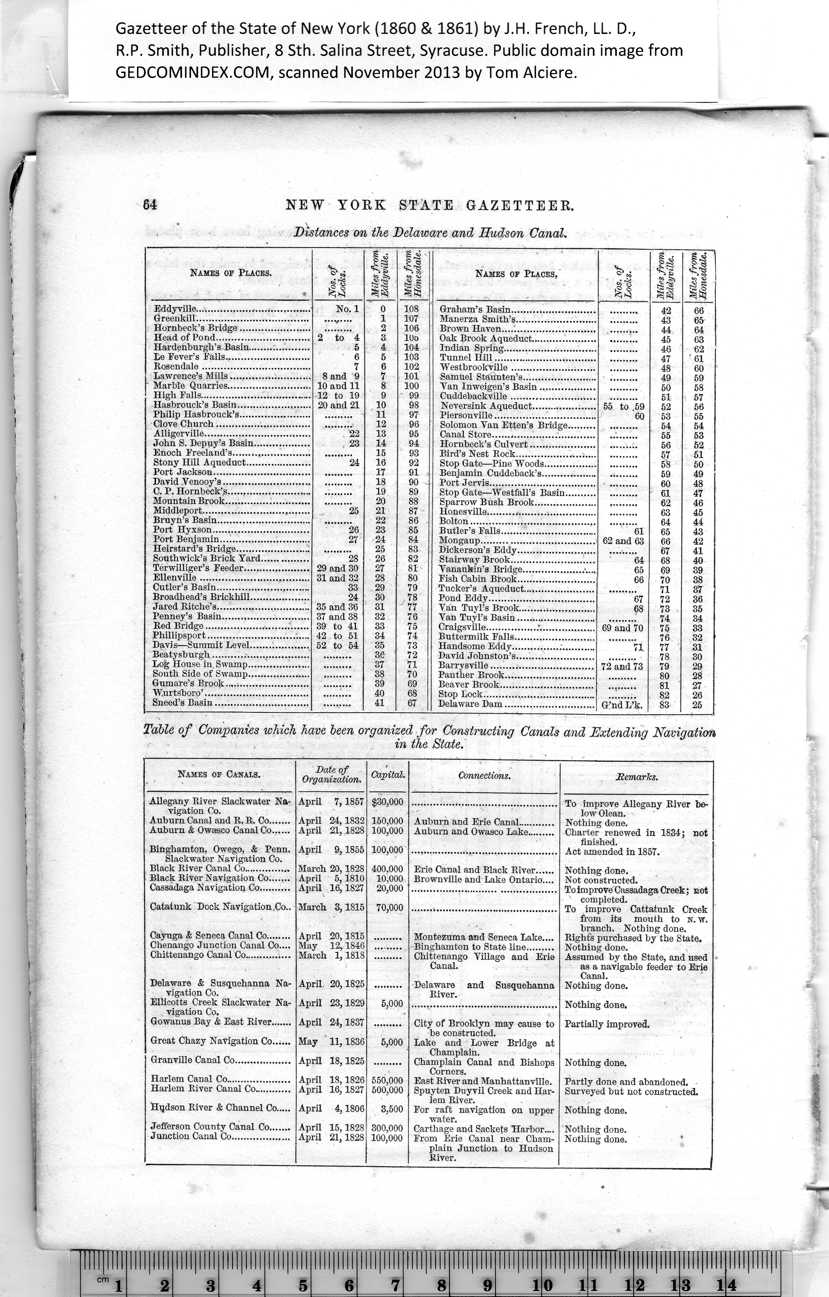
Eddyville......................

Greenkill......................

Hornbeck’s Bridge........

Head of Pond...............

Hardenburgh’s Basin.....

lie Fever's Falls............

Rosendale...................

Lawrence’s Mills ......

Marble Quarries...........

High Falls....................

Hasbrouclt’s Basin........

Philip Hasbrouck’s........

Clove Church...............

Alligerville...................

John S. Depuy’s Basin...

Enoch Freeland’s..........

Stony Hill Aqueduct.....

Port Jackson................

David Venooy’s.............

C. P. Hornbeck’s  .....

Mountain Brook............

Middleport...................

Bruyn’s Basin..............

Port Hyxson................

Port Benjamin..............

Heirstard’s Bridge........

Southwick’s Brick Yard.

Terwilliger’s Feeder......

Ellenville....................

Cutler’s Basin...............

Broadhead’s Brickhill....

Jared Ritche’s..............

Penney’s Basin.............

Red Bridge..................

Phillipsport.................

Davis—Summit Level....

Beatysburgh  .....

Log House in Swamp.....

South Side of Swamp....

Gumare’s Brook............

W.urtsboro’..................

Sneed’s Basin...............

Nos. of
Locks.

Miles from
Eddyville.

Miles from
Honesdale.

No. 1

0

108

1

107

2

106

2 to 4

3

10a

5

4

104

6

5

103

7

6

102

8 and 9

7

101

10 and 11

8

100

12 to 19

9

99

20 and 21

10

98

11

97

12

96

. 22

13

95

23

14

94

15

93

24

16

92

17

91

18

90

19

89

20

88

25

21

87

22

86

26

23

85

27

24

84

25

83

28

26

82

29 and 30

27

81

31 and 32

28

80

33

29

79

24

30

78

35 and 36

31

' 77

37 and 38

32

76

39 to 41

33

75

42 to 51

34

74

52 to 54

35

73

36

72

37

71

38

70

39

69

40

68

41

67

Names of Places,

Nos. of
Locks.

Miles from
Eddyville.

Miles from
Honesdale.

42

43

66

65

44

64

45

46

47

48

63

62

' 61

60

49

59

50

51

58

57

56

55 to .59
60

52

53

55

54

54

55

53

56

52

57

58

51

50

59

49

60

48

61

47

62

46

63

45

64

61

65

43

62 and 63

66

42

67

41

64

68

40

69

39

66

70

38

71

72

87

67

36

68

73

74

35

34

69 and 70

75

76

33

32

71

77

31

78

30

72 and 73

79

29

80

28

81

27

82

26

G’nd L’k.

83

25


Table of Companies which have been organized for Constructing Canals and Extending Navigation
in the State.

Names of Canals.


Connections.


Allegany River Slackwater Na¬
vigation Co.

Auburn Canal and R. R. Co.......

Auburn & Owasco Canal Co......

Binghamton, Owego, & Penn.
Slackwater Navigation Co.

Black River Canal Co...............

Black River Navigation Co.......

Cassadaga Navigation Co..........

Catatunk Dock Navigation .Co-


To improve Allegany River be¬
low Olean.

Nothing done.

Charter renewed in 1834; not
finished.

Act amended in 1857.

Nothing done.

Not constructed.

To improve Cassadaga Creek; not
completed.

To improve Cattatunk Creek
from its mouth to n. w.
branch. Nothing done.

Rights purchased by the State.

Nothing done.

Assumed by the State, and used
as a navigable feeder to Erie
Canal.

Nothing done.

Nothing done.

Partially improved.


Auburn and Erie Canal............

Auburn and Owasco Lake.........

Erie Canal and Black River......

Brownville and Lake Ontario....

Montezuma and Seneca Lake....

Binghamton to State line.........

Chittenango Village and Erie
Canal.


Delaware & Susquehanna Na¬
vigation Co.

Ellicotts Creek Slackwater Na¬
vigation Co.

Gowanus Bay & East River.......

Great Chazy Navigation Co......

Granville Canal Co..................

Harlem Canal Co.....................

Harlem River Canal Co............

Hqdson River & Channel Co.....

Jefferson County Canal Co.......

Junction Canal Co...................


and Susquehanna


City of Brooklyn may cause to
be constructed.

Lake and Lower Bridge at
Champlain.

Champlain Canal and Bishops
Corners.

East River and Manhattanville.

Spuyten Duyvil Creek and Har¬
lem River.

For raft navigation on upper
water.

Carthage and Sackets Harbor....

From Erie Canal near Cham¬
plain Junction to Hudson
River.


Nothing done.

Partly done and abandoned.
Surveyed but not constructed.

Nothing done.

Nothing done.
Nothing done.


Cayuga & Seneca Canal Co........

Chenango Junction Canal Co....
Chittenango Canal Co ...

Date of
Organization.

Capital.

April 7,1857

$30,000

April 24,1832
April 21,1828

150.000

100.000

April 9,1855

100,000

March 20,1828
April 5,1810
April 16,1827

400,000

10,000

20,000

March 3,1815

70,000

April 20,1815
May 12,1846
March 1,1818

..........

April 20,1825

.........

April 23,1829

5,000

April 24,1837

.........

May 11,1836

5,000

April 18,1825

.........

April 18,1826
April 16,1827

550.000

500.000

April 4,1806

3,500

April 15,1828
April 21,1828

300.000

100.000

Delaware

River.


PREVIOUS PAGE ... NEXT PAGE

This page was written in HTML using a program written in Python 3.2